
Topografische Karte Pabianice
Interaktive Karte
Klicken Sie auf die Karte, um die Höhe anzuzeigen.
Über diese Karte
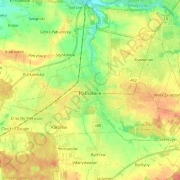
Name: Topografische Karte Pabianice, Höhe, Relief.
Ort: Pabianice, Pabianice County, Łódzkie Voivodship, Poland (51.63224 19.27419 51.69920 19.43554)
Durchschnittliche Höhe: 187 m
Minimale Höhe: 164 m
Maximale Höhe: 210 m
Andere topografische Karten
Klicken Sie auf eine Karte, um ihre Topografie, ihre Höhe und ihr Relief anzuzeigen.
Pawłówek
Poland > Łódzkie Voivodship > Pabianice County
Pawłówek, gmina Dłutów, Pabianice County, Łódzkie Voivodship, 95-081, Poland
Durchschnittliche Höhe: 198 m
Lutomiersk
Poland > Łódzkie Voivodship > Pabianice County
Lutomiersk, gmina Lutomiersk, Pabianice County, Łódzkie Voivodship, 95-083, Poland
Durchschnittliche Höhe: 165 m