
Topografische Karte Xhariep District Municipality
Interaktive Karte
Klicken Sie auf die Karte, um die Höhe anzuzeigen.
Über diese Karte
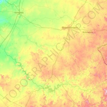
Name: Topografische Karte Xhariep District Municipality, Höhe, Relief.
Ort: Xhariep District Municipality, Free State, South Africa (-30.69408 24.34662 -28.82826 27.41033)
Durchschnittliche Höhe: 1.371 m
Minimale Höhe: 1.010 m
Maximale Höhe: 2.371 m
Andere topografische Karten
Klicken Sie auf eine Karte, um ihre Topografie, ihre Höhe und ihr Relief anzuzeigen.
Rainfall Dam
South Africa > Free State > Thabo Mofutsanyana District Municipality > Maluti-a-Phofung Local Municipality
Rainfall Dam, Maluti-a-Phofung Ward 22, Maluti-a-Phofung Local Municipality, Thabo Mofutsanyana District Municipality, Free State, South Africa
Durchschnittliche Höhe: 1.707 m
Meloding
South Africa > Free State > Lejweleputswa District Municipality > Matjhabeng Local Municipality
Meloding, Matjhabeng Local Municipality, Lejweleputswa District Municipality, Free State, South Africa
Durchschnittliche Höhe: 1.340 m
Koffiefontein
South Africa > Free State > Xhariep District Municipality > Letsemeng Local Municipality
Koffiefontein, Letsemeng Local Municipality, Xhariep District Municipality, Free State, South Africa
Durchschnittliche Höhe: 1.203 m
Bloemfontein
South Africa > Free State > Mangaung Metropolitan Municipality
Bloemfontein, Mangaung Metropolitan Municipality, Free State, 9301, South Africa
Durchschnittliche Höhe: 1.374 m
Swinburne
South Africa > Free State > Thabo Mofutsanyana District Municipality > Maluti-a-Phofung Local Municipality
Swinburne, Maluti-a-Phofung Local Municipality, Thabo Mofutsanyana District Municipality, Free State, South Africa
Durchschnittliche Höhe: 1.678 m
Vredefort
South Africa > Free State > Fezile Dabi District Municipality > Ngwathe Local Municipality > Vredefort
Vredefort, Ngwathe Local Municipality, Fezile Dabi District Municipality, Free State, 9595, South Africa
Durchschnittliche Höhe: 1.430 m
Grasslands
South Africa > Free State > Grasslands
Grasslands, Mangaung Metropolitan Municipality, Free State, 9364, South Africa
Durchschnittliche Höhe: 1.360 m
iNtabazwe (Harrismith)
South Africa > Free State > iNtabazwe (Harrismith)
iNtabazwe (Harrismith), Thabo Mofutsanyana District Municipality, Free State, 9880, South Africa
Durchschnittliche Höhe: 1.716 m
Maluti-a-Phofung Local Municipality
South Africa > Free State > Maluti-a-Phofung Local Municipality
Maluti-a-Phofung Local Municipality, Thabo Mofutsanyana District Municipality, Free State, South Africa
Durchschnittliche Höhe: 1.733 m