
Spenden
Rüste dich für dein nächstes Abenteuer:
Als Amazon-Partner verdient diese Website an qualifizierten Käufen, ohne zusätzliche Kosten für Sie.
Topografische Karte Kitimat
Klicken Sie auf die Karte, um die Höhe anzuzeigen.
Spenden
Rüste dich für dein nächstes Abenteuer:
Als Amazon-Partner verdient diese Website an qualifizierten Käufen, ohne zusätzliche Kosten für Sie.
Über diese Karte
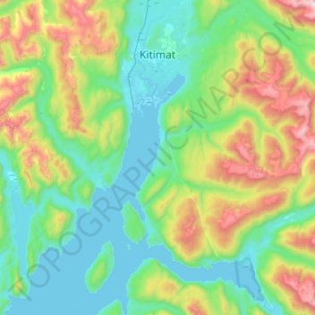
Name: Topografische Karte Kitimat, Höhe, Relief.
Durchschnittliche Höhe: 445 m
Minimale Höhe: -1 m
Maximale Höhe: 1.843 m
Spenden
Rüste dich für dein nächstes Abenteuer:
Als Amazon-Partner verdient diese Website an qualifizierten Käufen, ohne zusätzliche Kosten für Sie.
Andere topografische Karten
Klicken Sie auf eine Karte, um ihre Topografie, ihre Höhe und ihr Relief anzuzeigen.
Dease Lake
Canada > British Columbia > Regional District of Kitimat-Stikine > Area F (Dease Lake)
Dease Lake has a subarctic climate (Köppen Dfc), typical of northern British Columbia. Summers are mild, coupled with chilly nights while winters are severely cold and snowy, with annual snowfall averaging 212.8 cm (83.78 in). Autumn typically begins by early September and lasts into October when winter…
Durchschnittliche Höhe: 898 m
Meziadin Fishway
Canada > British Columbia > Regional District of Kitimat-Stikine > Area A (Nass Valley/Bell Irving)
Durchschnittliche Höhe: 261 m
Klemtu
Canada > British Columbia > Regional District of Kitimat-Stikine > Area C (Butedale/Kitlope/Kitsumkalum)
Durchschnittliche Höhe: 152 m
Anyox
Canada > British Columbia > Regional District of Kitimat-Stikine > Area A (Nass Valley/Bell Irving)
Durchschnittliche Höhe: 110 m
Spenden
Rüste dich für dein nächstes Abenteuer:
Als Amazon-Partner verdient diese Website an qualifizierten Käufen, ohne zusätzliche Kosten für Sie.
Mount Edziza
Canada > British Columbia > Regional District of Kitimat-Stikine > Area D (Iskut/Big Raven)
Mount Edziza (/ədˈzaɪzə/ əd-ZY-zə; Tahltan: Tenh Dẕetle [ten̥ ˈdðetle]) is a volcanic mountain in Cassiar Land District of northwestern British Columbia, Canada. It is located on the Big Raven Plateau of the Tahltan Highland which extends along the western side of the Stikine Plateau. Mount Edziza…
Durchschnittliche Höhe: 2.530 m
Nass Ranges
Canada > British Columbia > Regional District of Kitimat-Stikine > Area A (Nass Valley/Bell Irving)
Durchschnittliche Höhe: 951 m
Third Canyon
Canada > British Columbia > Regional District of Kitimat-Stikine > Area A (Nass Valley/Bell Irving)
Durchschnittliche Höhe: 305 m
South Hazelton
Canada > British Columbia > Regional District of Kitimat-Stikine > Area B (Suskwa/Kitwanga/Kispiox) > South Hazelton
Durchschnittliche Höhe: 278 m
Spenden
Rüste dich für dein nächstes Abenteuer:
Als Amazon-Partner verdient diese Website an qualifizierten Käufen, ohne zusätzliche Kosten für Sie.
Hoodoo Mountain
Canada > British Columbia > Regional District of Kitimat-Stikine > Area D (Iskut/Big Raven)
Hoodoo Mountain, sometimes referred to as Hoodoo Volcano, is a potentially active stratovolcano in the Northern Interior of British Columbia, Canada. It is located 25 kilometres (16 miles) northeast of the Alaska–British Columbia border on the north side of the Iskut River opposite of the mouth of the Craig…
Durchschnittliche Höhe: 1.657 m
Affleck Lake
Canada > British Columbia > Regional District of Kitimat-Stikine > Area B (Suskwa/Kitwanga/Kispiox)
Durchschnittliche Höhe: 417 m
Alice Arm
Canada > British Columbia > Regional District of Kitimat-Stikine > Area A (Nass Valley/Bell Irving)
Durchschnittliche Höhe: 186 m
Clearwater Lakes
Canada > British Columbia > Regional District of Kitimat-Stikine > Area C (Butedale/Kitlope/Kitsumkalum)
Durchschnittliche Höhe: 200 m
Spenden
Rüste dich für dein nächstes Abenteuer:
Als Amazon-Partner verdient diese Website an qualifizierten Käufen, ohne zusätzliche Kosten für Sie.
Beaver Lake
Canada > British Columbia > Regional District of Kitimat-Stikine > Area F (Dease Lake) > Dease Lake
Durchschnittliche Höhe: 865 m
Pentz Lake
Canada > British Columbia > Regional District of Kitimat-Stikine > Area B (Suskwa/Kitwanga/Kispiox)
Durchschnittliche Höhe: 356 m
40 Mile Flats
Canada > British Columbia > Regional District of Kitimat-Stikine > Area D (Iskut/Big Raven)
Durchschnittliche Höhe: 1.105 m
Iskut
Canada > British Columbia > Regional District of Kitimat-Stikine > Area D (Iskut/Big Raven)
Durchschnittliche Höhe: 930 m
Spenden
Rüste dich für dein nächstes Abenteuer:
Als Amazon-Partner verdient diese Website an qualifizierten Käufen, ohne zusätzliche Kosten für Sie.
Hagwilget
Canada > British Columbia > Regional District of Kitimat-Stikine > Area B (Suskwa/Kitwanga/Kispiox)
Durchschnittliche Höhe: 337 m
Atna Peak
Canada > British Columbia > Regional District of Kitimat-Stikine > Area C (Butedale/Kitlope/Kitsumkalum)
Durchschnittliche Höhe: 2.075 m
Thornhill
Canada > British Columbia > Regional District of Kitimat-Stikine > Area E (Thornhill)
Durchschnittliche Höhe: 117 m
Deep Creek
Canada > British Columbia > Regional District of Kitimat-Stikine > Area C (Butedale/Kitlope/Kitsumkalum)
Durchschnittliche Höhe: 133 m
Spenden
Rüste dich für dein nächstes Abenteuer:
Als Amazon-Partner verdient diese Website an qualifizierten Käufen, ohne zusätzliche Kosten für Sie.
Eve Cone
Canada > British Columbia > Regional District of Kitimat-Stikine > Area D (Iskut/Big Raven)
Eve Cone, sometimes referred to as Eve's Cone, is a cinder cone in Cassiar Land District of northwestern British Columbia, Canada. It has an elevation of 1,740 metres (5,710 feet) and is one of several volcanic cones in the Desolation Lava Field at the northern end of the Big Raven Plateau. The cone is…
Durchschnittliche Höhe: 1.607 m
Sandal Lake
Canada > British Columbia > Regional District of Kitimat-Stikine > Area A (Nass Valley/Bell Irving)
Durchschnittliche Höhe: 379 m
Ball Creek
Canada > British Columbia > Regional District of Kitimat-Stikine > Area D (Iskut/Big Raven)
Durchschnittliche Höhe: 1.228 m
Hazelton Mountains
Canada > British Columbia > Regional District of Kitimat-Stikine > Area B (Suskwa/Kitwanga/Kispiox)
Durchschnittliche Höhe: 1.117 m
Spenden
Rüste dich für dein nächstes Abenteuer:
Als Amazon-Partner verdient diese Website an qualifizierten Käufen, ohne zusätzliche Kosten für Sie.
Great Glacier
Canada > British Columbia > Regional District of Kitimat-Stikine > Area D (Iskut/Big Raven)
Durchschnittliche Höhe: 866 m
Cocoa Crater
Canada > British Columbia > Regional District of Kitimat-Stikine > Area D (Iskut/Big Raven)
Cocoa Crater, sometimes called Cocoa Cone, is a cinder cone in Cassiar Land District of northwestern British Columbia, Canada. It has an elevation of 2,117 metres (6,946 feet) and is one of several volcanic cones in the Snowshoe Lava Field at the southern end of the Big Raven Plateau. The cone is southeast of…
Durchschnittliche Höhe: 1.933 m
Coffee Crater
Canada > British Columbia > Regional District of Kitimat-Stikine > Area D (Iskut/Big Raven)
Coffee Crater is a cinder cone in Cassiar Land District of northwestern British Columbia, Canada. It has an elevation of 2,000 metres (6,600 feet) and is one of several volcanic cones in the Snowshoe Lava Field at the southern end of the Big Raven Plateau. The cone is southeast of the community of Telegraph…
Durchschnittliche Höhe: 1.888 m
Spectrum Range
Canada > British Columbia > Regional District of Kitimat-Stikine > Area D (Iskut/Big Raven)
Durchschnittliche Höhe: 1.669 m
Spenden
Rüste dich für dein nächstes Abenteuer:
Als Amazon-Partner verdient diese Website an qualifizierten Käufen, ohne zusätzliche Kosten für Sie.
Kitwanga
Canada > British Columbia > Regional District of Kitimat-Stikine > Area B (Suskwa/Kitwanga/Kispiox) > Kitwanga
Durchschnittliche Höhe: 329 m
Bell II
Canada > British Columbia > Regional District of Kitimat-Stikine > Area A (Nass Valley/Bell Irving) > Bell II
Durchschnittliche Höhe: 673 m
Terrace
Canada > British Columbia > Regional District of Kitimat-Stikine > Terrace > Terrace
Durchschnittliche Höhe: 121 m
Iskut River
Canada > British Columbia > Regional District of Kitimat-Stikine > Area D (Iskut/Big Raven)
Durchschnittliche Höhe: 932 m
Spenden
Rüste dich für dein nächstes Abenteuer:
Als Amazon-Partner verdient diese Website an qualifizierten Käufen, ohne zusätzliche Kosten für Sie.
Kitselas
Canada > British Columbia > Regional District of Kitimat-Stikine > Area C (Butedale/Kitlope/Kitsumkalum) > Kitselas
Durchschnittliche Höhe: 226 m
Tseax Cone
Canada > British Columbia > Regional District of Kitimat-Stikine > Area A (Nass Valley/Bell Irving)
Tseax Cone (/ˈsiːæks/ SEE-aks) is a small volcano in the Nass Ranges of the Hazelton Mountains in northwestern British Columbia, Canada. It has an elevation of 609 metres (1,998 feet) and lies within an east–west valley through which a tributary of the Tseax River flows. The volcano consists of two nested…
Durchschnittliche Höhe: 723 m
Hazelton
Canada > British Columbia > Regional District of Kitimat-Stikine > Hazelton > Hazelton
Durchschnittliche Höhe: 266 m
Ball Creek
Canada > British Columbia > Regional District of Kitimat-Stikine > Area F (Dease Lake)
Durchschnittliche Höhe: 1.267 m
Spenden
Rüste dich für dein nächstes Abenteuer:
Als Amazon-Partner verdient diese Website an qualifizierten Käufen, ohne zusätzliche Kosten für Sie.
Sixteen Mile Creek
Canada > British Columbia > Regional District of Kitimat-Stikine > Area F (Dease Lake)
Durchschnittliche Höhe: 1.267 m
Hoodoo Mountain
Canada > British Columbia > Regional District of Kitimat-Stikine > Area D (Iskut/Big Raven)
Hoodoo Mountain, sometimes referred to as Hoodoo Volcano, is a potentially active stratovolcano in the Northern Interior of British Columbia, Canada. It is located 25 kilometres (16 miles) northeast of the Alaska–British Columbia border on the north side of the Iskut River opposite of the mouth of the Craig…
Durchschnittliche Höhe: 1.657 m
Devils Thumb
Canada > British Columbia > Regional District of Kitimat-Stikine > Area D (Iskut/Big Raven)
Durchschnittliche Höhe: 1.718 m
Telegraph Creek
Canada > British Columbia > Regional District of Kitimat-Stikine > Area D (Iskut/Big Raven)
Durchschnittliche Höhe: 461 m
Spenden
Rüste dich für dein nächstes Abenteuer:
Als Amazon-Partner verdient diese Website an qualifizierten Käufen, ohne zusätzliche Kosten für Sie.
Dawes Glacier
Canada > British Columbia > Regional District of Kitimat-Stikine > Area D (Iskut/Big Raven)
Durchschnittliche Höhe: 1.348 m
Coast Mountains
Canada > British Columbia > Regional District of Kitimat-Stikine > Area A (Nass Valley/Bell Irving)
Durchschnittliche Höhe: 759 m
Klemtu
Canada > British Columbia > Regional District of Kitimat-Stikine > Area C (Butedale/Kitlope/Kitsumkalum)
Durchschnittliche Höhe: 152 m
Mount Dalton
Canada > British Columbia > Regional District of Kitimat-Stikine > Area F (Dease Lake)
Durchschnittliche Höhe: 1.658 m
Spenden
Rüste dich für dein nächstes Abenteuer:
Als Amazon-Partner verdient diese Website an qualifizierten Käufen, ohne zusätzliche Kosten für Sie.
Devils Thumb
Canada > British Columbia > Regional District of Kitimat-Stikine > Area D (Iskut/Big Raven)
Durchschnittliche Höhe: 1.718 m
Kitsault
Canada > British Columbia > Regional District of Kitimat-Stikine > Area A (Nass Valley/Bell Irving)
Durchschnittliche Höhe: 155 m
Hagwilget
Canada > British Columbia > Regional District of Kitimat-Stikine > Area B (Suskwa/Kitwanga/Kispiox)
Durchschnittliche Höhe: 337 m
Meziadin Junction
Canada > British Columbia > Regional District of Kitimat-Stikine > Area A (Nass Valley/Bell Irving)
Durchschnittliche Höhe: 345 m
Spenden
Rüste dich für dein nächstes Abenteuer:
Als Amazon-Partner verdient diese Website an qualifizierten Käufen, ohne zusätzliche Kosten für Sie.