Geolokalisieren

Topografische Karte Arlington

Klicken Sie auf die Karte, um die Höhe anzuzeigen.

Über diese Karte

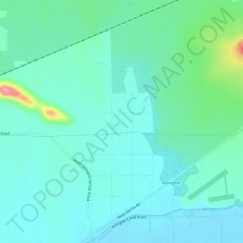
Name: Topografische Karte Arlington, Höhe, Relief.

Ort: Arlington, Maricopa County, Arizona, United States (33.31453 -112.79013 33.35748 -112.76192)

Durchschnittliche Höhe: 261 m

Minimale Höhe: 236 m

Maximale Höhe: 369 m

Andere topografische Karten

Klicken Sie auf eine Karte, um ihre Topografie, ihre Höhe und ihr Relief anzuzeigen.

Surprise

United States > Arizona > Maricopa County > Surprise

Durchschnittliche Höhe: 410 m

Gilbert

United States > Arizona > Maricopa County > Gilbert

Durchschnittliche Höhe: 400 m

Mesa

United States > Arizona > Maricopa County

Durchschnittliche Höhe: 399 m

Waddell

United States > Arizona > Maricopa County

Durchschnittliche Höhe: 369 m

Cotton Center

United States > Arizona > Maricopa County > Gila Bend

Durchschnittliche Höhe: 219 m

Palo Verde

United States > Arizona > Maricopa County

Durchschnittliche Höhe: 257 m

Sundad

United States > Arizona > Maricopa County

Sundad is an unincorporated area in the far west of Maricopa County, Arizona, United States, along the border of Yuma County. It has an estimated elevation of 965 feet (294 m) above sea level. It is located north of Agua Caliente and east of Sacation Flats.

Durchschnittliche Höhe: 300 m

Wittmann

United States > Arizona > Maricopa County

Durchschnittliche Höhe: 516 m

El Mirage

United States > Arizona > Maricopa County

Durchschnittliche Höhe: 352 m

Paradise Valley

United States > Arizona > Maricopa County

Durchschnittliche Höhe: 424 m

Sonoran Preserve

United States > Arizona > Maricopa County > Phoenix

Durchschnittliche Höhe: 521 m

Youngtown

United States > Arizona > Maricopa County

Durchschnittliche Höhe: 341 m

Tonopah

United States > Arizona > Maricopa County

Durchschnittliche Höhe: 342 m

Anthem

United States > Arizona > Maricopa County > Anthem

Anthem is built on 5,856 acres (9.2 sq mi) at the base of Daisy Mountain and Gavilan Peak. The community's elevation ranges from 1,760 feet to 2,428 feet, with an average elevation of 1,863 feet. Approximately 36 percent of the community is preserved as open space, including 291 acres of open hillside.

Durchschnittliche Höhe: 580 m

Litchfield Park

United States > Arizona > Maricopa County

Durchschnittliche Höhe: 319 m

New River

United States > Arizona > Maricopa County > Phoenix

Durchschnittliche Höhe: 690 m

Pinnacle Peak

United States > Arizona > Maricopa County > Scottsdale

Pinnacle Peak is a granite summit located in Scottsdale, Arizona. The peak rises to an elevation of 3,169 feet (966 m). It is located within the 150-acre (61 ha) Pinnacle Peak Park, operated by the City of Scottsdale Park District. Part of the Sonoran Desert, the park is home to a variety of native desert…

Durchschnittliche Höhe: 753 m

Tempe

United States > Arizona > Maricopa County > Tempe

Tempe is generally flat, except for Hayden Butte (generally known as A-Mountain for Arizona State University's "A" logo located on its south face), located next to Sun Devil Stadium, Twin Buttes and Bell Butte on the western edge of Tempe, and Papago Park northwest of Tempe, inside Phoenix. Elevation ranges…

Durchschnittliche Höhe: 386 m

Salt River

United States > Arizona > Maricopa County > Scottsdale

Salt River is a populated place situated in Maricopa County, Arizona, United States. It has an estimated elevation of 1,220 feet (370 m) above sea level. It is located on the Salt River Pima–Maricopa Indian Community.

Durchschnittliche Höhe: 372 m

Saguaro Lake

United States > Arizona > Maricopa County

Durchschnittliche Höhe: 574 m

Peoria

United States > Arizona > Maricopa County > Peoria

Durchschnittliche Höhe: 366 m

Phoenix

United States > Arizona > Maricopa County > Phoenix

Phoenix is in the south-central portion of Arizona; about halfway between Tucson to the southeast and Flagstaff to the north, in the southwestern United States. By car, the city is approximately 150 miles (240 kilometers) north of the US–Mexico border at Sonoyta and 180 mi (290 km) north of the border at…

Durchschnittliche Höhe: 368 m

Glendale

United States > Arizona > Maricopa County > Glendale

Durchschnittliche Höhe: 358 m

Avondale

United States > Arizona > Maricopa County > Avondale

Durchschnittliche Höhe: 340 m

Brown's Mountain

United States > Arizona > Maricopa County > Scottsdale

Durchschnittliche Höhe: 827 m

Bosque

United States > Arizona > Maricopa County

Durchschnittliche Höhe: 300 m

Point of Rocks

United States > Arizona > Maricopa County

Durchschnittliche Höhe: 198 m

Verrado

United States > Arizona > Maricopa County > Buckeye

Durchschnittliche Höhe: 410 m

Chinese Wall

United States > Arizona > Maricopa County > Phoenix

Durchschnittliche Höhe: 641 m

Butte Peak

United States > Arizona > Maricopa County > Scottsdale

Durchschnittliche Höhe: 1.279 m

Quien Sabe Peak

United States > Arizona > Maricopa County

Durchschnittliche Höhe: 1.263 m

Willow Spring Mountain

United States > Arizona > Maricopa County

Durchschnittliche Höhe: 1.238 m

Tom's Thumb

United States > Arizona > Maricopa County > Scottsdale

Durchschnittliche Höhe: 981 m

Bartlett Reservoir

United States > Arizona > Maricopa County

Durchschnittliche Höhe: 720 m

Sun City West

United States > Arizona > Maricopa County

Durchschnittliche Höhe: 381 m

Citrus Park

United States > Arizona > Maricopa County

Durchschnittliche Höhe: 360 m

Canyon Lake Marina

United States > Arizona > Maricopa County

Durchschnittliche Höhe: 604 m

Rio Verde

United States > Arizona > Maricopa County

Durchschnittliche Höhe: 487 m

Camp Creek

United States > Arizona > Maricopa County

Durchschnittliche Höhe: 1.127 m

Sun Lakes

United States > Arizona > Maricopa County

Durchschnittliche Höhe: 365 m

Desert West Lake

United States > Arizona > Maricopa County > Phoenix

Durchschnittliche Höhe: 330 m

Fort McDowell

United States > Arizona > Maricopa County

Durchschnittliche Höhe: 447 m

Boulder Mountain

United States > Arizona > Maricopa County > Mesa

Durchschnittliche Höhe: 500 m

Sunset Point

United States > Arizona > Maricopa County > Glendale

Durchschnittliche Höhe: 328 m

Chandler

United States > Arizona > Maricopa County > Chandler

Durchschnittliche Höhe: 386 m

Union Peak

United States > Arizona > Maricopa County > Phoenix

Durchschnittliche Höhe: 527 m

Cottonwoods Spring

United States > Arizona > Maricopa County

Durchschnittliche Höhe: 1.018 m

Goodyear

United States > Arizona > Maricopa County > Goodyear > Goodyear

Durchschnittliche Höhe: 295 m

Liberty

United States > Arizona > Maricopa County

Durchschnittliche Höhe: 268 m

Sentinel

United States > Arizona > Maricopa County

Sentinel is an unincorporated community in Maricopa County, Arizona, United States. It has an estimated elevation of 692 feet (211 m) above sea level.

Durchschnittliche Höhe: 213 m

Mobile

United States > Arizona > Maricopa County > Mobile

Durchschnittliche Höhe: 402 m

Rüste dich für dein nächstes Abenteuer:

🧰Multitools - Vielseitige Werkzeuge für Outdoor-Einsätze
👟Trailrunning Schuhe - Leichte Alternative zu Wanderschuhen für schnelles Gelände
🧦Wandersocken Merinowolle - Keine Blasenbildung und optimale Temperaturregulierung
📱GPS fürs Wandern - Digitale Navigation für Tourenplanung
🧯Notfallausrüstung - Sicher vorbereitet in der Natur

Als Amazon-Partner verdient diese Website an qualifizierten Käufen, ohne zusätzliche Kosten für Sie.