
Topografische Karte American Fork
Interaktive Karte
Klicken Sie auf die Karte, um die Höhe anzuzeigen.
Über diese Karte
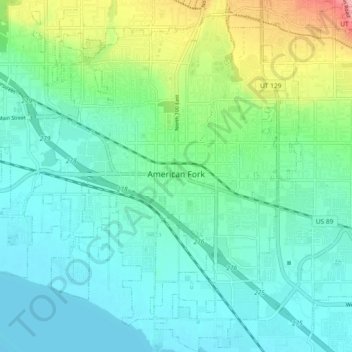
Name: Topografische Karte American Fork, Höhe, Relief.
Ort: American Fork, Utah County, Utah, 84003, United States (40.34104 -111.83628 40.41170 -111.76361)
Durchschnittliche Höhe: 1.405 m
Minimale Höhe: 1.366 m
Maximale Höhe: 1.537 m
Elevations throughout the city range from 4,566 feet (1,392 m) to 4,619 feet (1,408 m) above sea level.
Andere topografische Karten
Klicken Sie auf eine Karte, um ihre Topografie, ihre Höhe und ihr Relief anzuzeigen.
Wildwood
United States > Utah > Utah County
Wildwood, Utah County, Utah, United States
Durchschnittliche Höhe: 1.879 m
Provo
United States > Utah > Utah County > Provo
Provo, Utah County, Utah, 84606, United States
Durchschnittliche Höhe: 1.733 m
Townsend
United States > Utah > Utah County > Genola > Townsend
Townsend, Genola, Utah County, Utah, United States
Durchschnittliche Höhe: 1.438 m
Spanish Fork
United States > Utah > Utah County
Spanish Fork, Utah County, Utah, 84660, United States
Durchschnittliche Höhe: 1.407 m
Provo
United States > Utah > Utah County
Provo, Utah County, Utah, United States
Durchschnittliche Höhe: 1.728 m