
Topografische Karte Wildwood
Interaktive Karte
Klicken Sie auf die Karte, um die Höhe anzuzeigen.
Über diese Karte
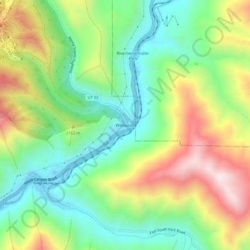
Name: Topografische Karte Wildwood, Höhe, Relief.
Ort: Wildwood, Utah County, Utah, United States (40.34523 -111.57742 40.38523 -111.53742)
Durchschnittliche Höhe: 1.879 m
Minimale Höhe: 1.583 m
Maximale Höhe: 2.347 m
Andere topografische Karten
Klicken Sie auf eine Karte, um ihre Topografie, ihre Höhe und ihr Relief anzuzeigen.
American Fork
United States > Utah > Utah County
American Fork, Utah County, Utah, 84003, United States
Durchschnittliche Höhe: 1.405 m
Provo
United States > Utah > Utah County > Provo
Provo, Utah County, Utah, 84606, United States
Durchschnittliche Höhe: 1.733 m
Townsend
United States > Utah > Utah County > Genola > Townsend
Townsend, Genola, Utah County, Utah, United States
Durchschnittliche Höhe: 1.438 m
Spanish Fork
United States > Utah > Utah County
Spanish Fork, Utah County, Utah, 84660, United States
Durchschnittliche Höhe: 1.407 m
Provo
United States > Utah > Utah County
Provo, Utah County, Utah, United States
Durchschnittliche Höhe: 1.728 m