
Topografische Karte Oaks Bottom Wildlife Refuge
Interaktive Karte
Klicken Sie auf die Karte, um die Höhe anzuzeigen.
Über diese Karte
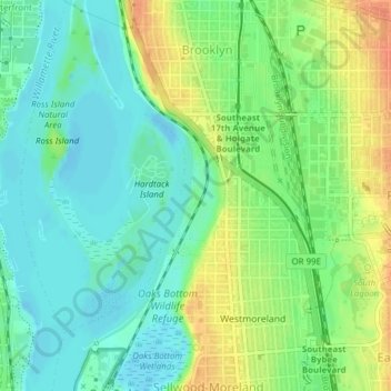
Name: Topografische Karte Oaks Bottom Wildlife Refuge, Höhe, Relief.
Durchschnittliche Höhe: 17 m
Minimale Höhe: -3 m
Maximale Höhe: 43 m
Andere topografische Karten
Klicken Sie auf eine Karte, um ihre Topografie, ihre Höhe und ihr Relief anzuzeigen.
Eastmoreland
Eastmoreland, Portland, Multnomah County, Oregon, 97202, USA
Durchschnittliche Höhe: 42 m
Hoyt Arboretum
Hoyt Arboretum, Arlington Heights, Portland, Multnomah County, Oregon, USA
Durchschnittliche Höhe: 209 m
Powell Butte Nature Park
Powell Butte Nature Park, Pleasant Valley, Portland, Multnomah County, Oregon, USA
Durchschnittliche Höhe: 123 m
Northwest District
Northwest District, Portland, Multnomah County, Oregon, 97210, USA
Durchschnittliche Höhe: 52 m
Hosford-Abernethy
Hosford-Abernethy, Portland, Multnomah County, Oregon, USA
Durchschnittliche Höhe: 26 m