
Topografische Karte Buckman
Interaktive Karte
Klicken Sie auf die Karte, um die Höhe anzuzeigen.
Über diese Karte
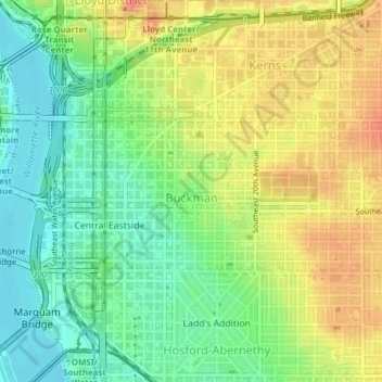
Name: Topografische Karte Buckman, Höhe, Relief.
Ort: Buckman, Portland, Multnomah County, Oregon, 97214, USA (45.51207 -122.67094 45.52360 -122.63709)
Durchschnittliche Höhe: 30 m
Minimale Höhe: 3 m
Maximale Höhe: 62 m
Andere topografische Karten
Klicken Sie auf eine Karte, um ihre Topografie, ihre Höhe und ihr Relief anzuzeigen.
Eastmoreland
Eastmoreland, Portland, Multnomah County, Oregon, 97202, USA
Durchschnittliche Höhe: 42 m
Hoyt Arboretum
Hoyt Arboretum, Arlington Heights, Portland, Multnomah County, Oregon, USA
Durchschnittliche Höhe: 209 m
Powell Butte Nature Park
Powell Butte Nature Park, Pleasant Valley, Portland, Multnomah County, Oregon, USA
Durchschnittliche Höhe: 123 m
Northwest District
Northwest District, Portland, Multnomah County, Oregon, 97210, USA
Durchschnittliche Höhe: 52 m
Hosford-Abernethy
Hosford-Abernethy, Portland, Multnomah County, Oregon, USA
Durchschnittliche Höhe: 26 m
Oaks Bottom Wildlife Refuge
Oaks Bottom Wildlife Refuge, Westmoreland, Sellwood-Moreland, Portland, Multnomah County, Oregon, USA
Durchschnittliche Höhe: 17 m
Woodland Park
Woodland Park, Portland, Multnomah County, Oregon, USA
Durchschnittliche Höhe: 85 m
Smith and Bybee Wetlands Natural Area
Smith and Bybee Wetlands Natural Area, St. Johns, Portland, Multnomah County, Oregon, USA
Durchschnittliche Höhe: 10 m