
Topografische Karte Stone Island
Interaktive Karte
Klicken Sie auf die Karte, um die Höhe anzuzeigen.
Über diese Karte
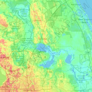
Name: Topografische Karte Stone Island, Höhe, Relief.
Ort: Stone Island, Volusia County, Florida, 32728, United States (28.52999 -81.55590 29.16999 -80.91590)
Durchschnittliche Höhe: 14 m
Minimale Höhe: -4 m
Maximale Höhe: 56 m
Andere topografische Karten
Klicken Sie auf eine Karte, um ihre Topografie, ihre Höhe und ihr Relief anzuzeigen.
Ponce Inlet
United States > Florida > Volusia County
Ponce Inlet, Volusia County, Florida, United States
Durchschnittliche Höhe: 1 m
DeLand
United States > Florida > Volusia County
DeLand, Volusia County, Florida, 32723, United States
Durchschnittliche Höhe: 20 m
Deltona
United States > Florida > Volusia County > Deltona
Deltona, Volusia County, Florida, 32725, United States
Durchschnittliche Höhe: 12 m
Port Orange
United States > Florida > Volusia County
Port Orange, Volusia County, Florida, United States
Durchschnittliche Höhe: 6 m
Daytona Beach
United States > Florida > Volusia County
Daytona Beach, Volusia County, Florida, United States
Durchschnittliche Höhe: 5 m
Orange City
United States > Florida > Volusia County
Orange City, Volusia County, Florida, 32763, United States
Durchschnittliche Höhe: 18 m