
Topografische Karte Sancerre
Interaktive Karte
Klicken Sie auf die Karte, um die Höhe anzuzeigen.
Über diese Karte
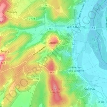
Name: Topografische Karte Sancerre, Höhe, Relief.
Durchschnittliche Höhe: 212 m
Minimale Höhe: 141 m
Maximale Höhe: 352 m
Sancerre est située à 310 mètres d'altitude, sur une montagne isolée, se rattachant aux collines de la région naturelle du Sancerrois et dont le sommet domine le niveau de la Loire de deux cents mètres.
Andere topografische Karten
Klicken Sie auf eine Karte, um ihre Topografie, ihre Höhe und ihr Relief anzuzeigen.
Les Beauchots
France > Centre-Val de Loire > Cher > Assigny
Les Beauchots, Assigny, Bourges, Cher, Centre-Val de Loire, France métropolitaine, 18260, France
Durchschnittliche Höhe: 245 m
Argent-sur-Sauldre
France > Centre-Val de Loire > Cher
Argent-sur-Sauldre, Vierzon, Cher, Centre-Val de Loire, France métropolitaine, 18410, France
Durchschnittliche Höhe: 176 m
Sévry
France > Centre-Val de Loire > Cher
Sévry, Bourges, Cher, Centre-Val de Loire, France métropolitaine, 18140, France
Durchschnittliche Höhe: 203 m
Vierzon
France > Centre-Val de Loire > Cher
Vierzon, Cher, Centre-Val de Loire, France métropolitaine, 18100, France
Durchschnittliche Höhe: 137 m
Cuffy
France > Centre-Val de Loire > Cher
Cuffy, Saint-Amand-Montrond, Cher, Centre-Val de Loire, France métropolitaine, 18150, France
Durchschnittliche Höhe: 190 m
La Chapelle-Saint-Ursin
France > Centre-Val de Loire > Cher
La Chapelle-Saint-Ursin, Bourges, Cher, Centre-Val de Loire, France métropolitaine, 18570, France
Durchschnittliche Höhe: 147 m
Les Grands Bois Marteau
France > Centre-Val de Loire > Cher > Vierzon
Les Grands Bois Marteau, Vierzon, Cher, Centre-Val de Loire, France métropolitaine, 18100, France
Durchschnittliche Höhe: 130 m
Bengy-sur-Craon
France > Centre-Val de Loire > Cher
Bengy-sur-Craon, Bourges, Cher, Centre-Val de Loire, France métropolitaine, 18520, France
Durchschnittliche Höhe: 193 m
Jars
France > Centre-Val de Loire > Cher
Jars, Bourges, Cher, Centre-Val de Loire, France métropolitaine, 18260, France
Durchschnittliche Höhe: 255 m
Allouis
France > Centre-Val de Loire > Cher
Allouis, Vierzon, Cher, Centre-Val de Loire, France métropolitaine, 18500, France
Durchschnittliche Höhe: 130 m
Le Châtelet
France > Centre-Val de Loire > Cher > Le Châtelet
Le Châtelet, Saint-Amand-Montrond, Cher, Centre-Val de Loire, France métropolitaine, 18170, France
Durchschnittliche Höhe: 231 m
Bourges
France > Centre-Val de Loire > Cher
Bourges, Cher, Centre-Val de Loire, France métropolitaine, 18000, France
Durchschnittliche Höhe: 146 m