
Topografische Karte Cuffy
Interaktive Karte
Klicken Sie auf die Karte, um die Höhe anzuzeigen.
Über diese Karte
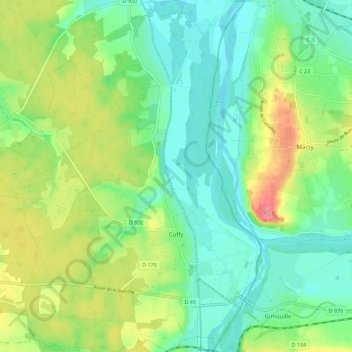
Name: Topografische Karte Cuffy, Höhe, Relief.
Durchschnittliche Höhe: 190 m
Minimale Höhe: 162 m
Maximale Höhe: 244 m
Andere topografische Karten
Klicken Sie auf eine Karte, um ihre Topografie, ihre Höhe und ihr Relief anzuzeigen.
Les Beauchots
France > Centre-Val de Loire > Cher > Assigny
Les Beauchots, Assigny, Bourges, Cher, Centre-Val de Loire, France métropolitaine, 18260, France
Durchschnittliche Höhe: 245 m
Argent-sur-Sauldre
France > Centre-Val de Loire > Cher
Argent-sur-Sauldre, Vierzon, Cher, Centre-Val de Loire, France métropolitaine, 18410, France
Durchschnittliche Höhe: 176 m
Sévry
France > Centre-Val de Loire > Cher
Sévry, Bourges, Cher, Centre-Val de Loire, France métropolitaine, 18140, France
Durchschnittliche Höhe: 203 m
Vierzon
France > Centre-Val de Loire > Cher
Vierzon, Cher, Centre-Val de Loire, France métropolitaine, 18100, France
Durchschnittliche Höhe: 137 m
La Chapelle-Saint-Ursin
France > Centre-Val de Loire > Cher
La Chapelle-Saint-Ursin, Bourges, Cher, Centre-Val de Loire, France métropolitaine, 18570, France
Durchschnittliche Höhe: 147 m
Les Grands Bois Marteau
France > Centre-Val de Loire > Cher > Vierzon
Les Grands Bois Marteau, Vierzon, Cher, Centre-Val de Loire, France métropolitaine, 18100, France
Durchschnittliche Höhe: 130 m
Bengy-sur-Craon
France > Centre-Val de Loire > Cher
Bengy-sur-Craon, Bourges, Cher, Centre-Val de Loire, France métropolitaine, 18520, France
Durchschnittliche Höhe: 193 m
Jars
France > Centre-Val de Loire > Cher
Jars, Bourges, Cher, Centre-Val de Loire, France métropolitaine, 18260, France
Durchschnittliche Höhe: 255 m
Allouis
France > Centre-Val de Loire > Cher
Allouis, Vierzon, Cher, Centre-Val de Loire, France métropolitaine, 18500, France
Durchschnittliche Höhe: 130 m
Le Châtelet
France > Centre-Val de Loire > Cher > Le Châtelet
Le Châtelet, Saint-Amand-Montrond, Cher, Centre-Val de Loire, France métropolitaine, 18170, France
Durchschnittliche Höhe: 231 m
Bourges
France > Centre-Val de Loire > Cher
Bourges, Cher, Centre-Val de Loire, France métropolitaine, 18000, France
Durchschnittliche Höhe: 146 m
Sancerre
France > Centre-Val de Loire > Cher
Sancerre, Bourges, Cher, Centre-Val de Loire, France métropolitaine, 18300, France
Durchschnittliche Höhe: 212 m