
Topografische Karte Poznań
Interaktive Karte
Klicken Sie auf die Karte, um die Höhe anzuzeigen.
Über diese Karte
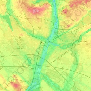
Name: Topografische Karte Poznań, Höhe, Relief.
Ort: Poznań, Poznań County, Greater Poland Voivodeship, Poland (52.29192 16.73159 52.50933 17.07171)
Durchschnittliche Höhe: 85 m
Minimale Höhe: 45 m
Maximale Höhe: 146 m
Andere topografische Karten
Klicken Sie auf eine Karte, um ihre Topografie, ihre Höhe und ihr Relief anzuzeigen.
Kórnik
Poland > Greater Poland Voivodeship > Poznań County
Kórnik, gmina Kórnik, Poznań County, Greater Poland Voivodeship, 62-035, Poland
Durchschnittliche Höhe: 75 m
Owińska
Poland > Greater Poland Voivodeship > Poznań County > Owińska
Owińska, gmina Czerwonak, Poznań County, Greater Poland Voivodeship, 62-009, Poland
Durchschnittliche Höhe: 74 m
Poznań
Poland > Greater Poland Voivodeship > Poznań County
Poznań, Poznań County, Greater Poland Voivodeship, Poland
Durchschnittliche Höhe: 85 m
Mosina
Poland > Greater Poland Voivodeship > Poznań County
Mosina, gmina Mosina, Poznań County, Greater Poland Voivodeship, 62-050, Poland
Durchschnittliche Höhe: 71 m