
Topografische Karte Kórnik
Interaktive Karte
Klicken Sie auf die Karte, um die Höhe anzuzeigen.
Über diese Karte
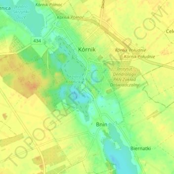
Name: Topografische Karte Kórnik, Höhe, Relief.
Durchschnittliche Höhe: 75 m
Minimale Höhe: 60 m
Maximale Höhe: 86 m
Andere topografische Karten
Klicken Sie auf eine Karte, um ihre Topografie, ihre Höhe und ihr Relief anzuzeigen.
Owińska
Poland > Greater Poland Voivodeship > Poznań County > Owińska
Owińska, gmina Czerwonak, Poznań County, Greater Poland Voivodeship, 62-009, Poland
Durchschnittliche Höhe: 74 m
Poznań
Poland > Greater Poland Voivodeship > Poznań County
Poznań, Poznań County, Greater Poland Voivodeship, Poland
Durchschnittliche Höhe: 85 m
Mosina
Poland > Greater Poland Voivodeship > Poznań County
Mosina, gmina Mosina, Poznań County, Greater Poland Voivodeship, 62-050, Poland
Durchschnittliche Höhe: 71 m
Poznań
Poland > Greater Poland Voivodeship > Poznań County
Poznań, Poznań County, Greater Poland Voivodeship, Poland
Durchschnittliche Höhe: 85 m