
Topografische Karte Flagstaff
Interaktive Karte
Klicken Sie auf die Karte, um die Höhe anzuzeigen.
Über diese Karte
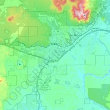
Name: Topografische Karte Flagstaff, Höhe, Relief.
Ort: Flagstaff, Coconino County, Arizona, United States (35.12240 -111.70894 35.24010 -111.50678)
Durchschnittliche Höhe: 2.151 m
Minimale Höhe: 1.962 m
Maximale Höhe: 2.828 m
Flagstaff is the county seat of Coconino County. According to the United States Census Bureau, the city has a total area of 63.9 square miles (165.5 km2), of which only 0.03 square miles (0.08 km2) (0.08%) is water. Flagstaff lies at approximately 7,000 feet (2,130 m) elevation, and is surrounded by the largest contiguous ponderosa pine forest in North America. It is in a mountainous area, and lies along the Rio de Flag watercourse. It is about 130 miles (210 km) north of the State capital, Phoenix.
Andere topografische Karten
Klicken Sie auf eine Karte, um ihre Topografie, ihre Höhe und ihr Relief anzuzeigen.
Williams
United States > Arizona > Coconino County
Williams, Coconino County, Arizona, 86046, United States
Durchschnittliche Höhe: 2.131 m
Grand Canyon Village
United States > Arizona > Coconino County
Grand Canyon Village, Coconino County, Arizona, United States
Durchschnittliche Höhe: 1.778 m
Sunset Crater
United States > Arizona > Coconino County
Sunset Crater, Coconino County, Arizona, United States
Durchschnittliche Höhe: 2.168 m
Antelope Canyon
United States > Arizona > Coconino County
Antelope Canyon, Coconino County, Arizona, United States
Durchschnittliche Höhe: 1.202 m
One Mile
United States > Arizona > Coconino County
One Mile, Coconino County, Arizona, United States
Durchschnittliche Höhe: 1.817 m
The Gap
United States > Arizona > Coconino County > The Gap
The Gap, Coconino County, Arizona, United States
Durchschnittliche Höhe: 1.673 m
Jack Stephens Tank
United States > Arizona > Coconino County
Jack Stephens Tank, Coconino County, Arizona, United States
Durchschnittliche Höhe: 1.851 m
Grand Canyon
United States > Arizona > Coconino County
Grand Canyon, Coconino County, Arizona, United States
Durchschnittliche Höhe: 1.021 m