
Topografische Karte Antelope Canyon
Interaktive Karte
Klicken Sie auf die Karte, um die Höhe anzuzeigen.
Über diese Karte
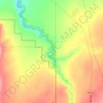
Name: Topografische Karte Antelope Canyon, Höhe, Relief.
Ort: Antelope Canyon, Coconino County, Arizona, United States (36.92755 -111.42537 36.93524 -111.42103)
Durchschnittliche Höhe: 1.202 m
Minimale Höhe: 1.121 m
Maximale Höhe: 1.260 m
Andere topografische Karten
Klicken Sie auf eine Karte, um ihre Topografie, ihre Höhe und ihr Relief anzuzeigen.
Williams
United States > Arizona > Coconino County
Williams, Coconino County, Arizona, 86046, United States
Durchschnittliche Höhe: 2.131 m
Grand Canyon Village
United States > Arizona > Coconino County
Grand Canyon Village, Coconino County, Arizona, United States
Durchschnittliche Höhe: 1.778 m
Sunset Crater
United States > Arizona > Coconino County
Sunset Crater, Coconino County, Arizona, United States
Durchschnittliche Höhe: 2.168 m
One Mile
United States > Arizona > Coconino County
One Mile, Coconino County, Arizona, United States
Durchschnittliche Höhe: 1.817 m
Flagstaff
United States > Arizona > Coconino County
Flagstaff, Coconino County, Arizona, United States
Durchschnittliche Höhe: 2.151 m
The Gap
United States > Arizona > Coconino County > The Gap
The Gap, Coconino County, Arizona, United States
Durchschnittliche Höhe: 1.673 m
Jack Stephens Tank
United States > Arizona > Coconino County
Jack Stephens Tank, Coconino County, Arizona, United States
Durchschnittliche Höhe: 1.851 m
Grand Canyon
United States > Arizona > Coconino County
Grand Canyon, Coconino County, Arizona, United States
Durchschnittliche Höhe: 1.021 m