
Topografische Karte Hope Mills
Interaktive Karte
Klicken Sie auf die Karte, um die Höhe anzuzeigen.
Über diese Karte
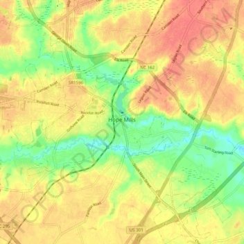
Name: Topografische Karte Hope Mills, Höhe, Relief.
Ort: Hope Mills, Cumberland County, North Carolina, United States (34.92947 -78.99355 35.00970 -78.90120)
Durchschnittliche Höhe: 49 m
Minimale Höhe: 19 m
Maximale Höhe: 69 m
Andere topografische Karten
Klicken Sie auf eine Karte, um ihre Topografie, ihre Höhe und ihr Relief anzuzeigen.
Fayetteville
United States > North Carolina > Cumberland County
Fayetteville, Cumberland County, North Carolina, United States
Durchschnittliche Höhe: 48 m
Eaglewood Forest
United States > North Carolina > Cumberland County > Hope Mills
Eaglewood Forest, Hope Mills, Cumberland County, North Carolina, 28306, United States
Durchschnittliche Höhe: 45 m
The Greens
United States > North Carolina > Cumberland County > Fayetteville
The Greens, Fayetteville, Cumberland County, North Carolina, 28311, United States
Durchschnittliche Höhe: 52 m
Hillendale
United States > North Carolina > Cumberland County > Fayetteville
Hillendale, Fayetteville, Cumberland County, North Carolina, 28311, United States
Durchschnittliche Höhe: 61 m
Winter Park
United States > North Carolina > Cumberland County > Fayetteville
Winter Park, Fayetteville, Cumberland County, North Carolina, 28304, United States
Durchschnittliche Höhe: 58 m
Williams Village
United States > North Carolina > Cumberland County > Fayetteville
Williams Village, Fayetteville, Cumberland County, North Carolina, 28301, United States
Durchschnittliche Höhe: 30 m