
Topografische Karte Oakland
Interaktive Karte
Klicken Sie auf die Karte, um die Höhe anzuzeigen.
Über diese Karte
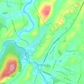
Name: Topografische Karte Oakland, Höhe, Relief.
Ort: Oakland, Garrett County, Maryland, United States (39.39996 -79.42436 39.44366 -79.37775)
Durchschnittliche Höhe: 763 m
Minimale Höhe: 712 m
Maximale Höhe: 879 m
Oakland, owing to its high elevation and valley location, is among the coldest and snowiest locales in the state of Maryland, and has a warm-summer humid continental climate (Köppen Dfb). The state record low of −40 °F or −40 °C was recorded here on January 13, 1912. The monthly mean temperature ranges from 25.1 °F (−3.8 °C) in January to 68.4 °F (20.2 °C) in July, with temperatures not reaching above freezing on an average 34 afternoons and falling to 0 °F (−17.8 °C) or below on an average of 5.8 mornings. The average first and last dates for freezing temperatures are September 28 and May 15, respectively.
Andere topografische Karten
Klicken Sie auf eine Karte, um ihre Topografie, ihre Höhe und ihr Relief anzuzeigen.
Swanton
United States > Maryland > Garrett County
Swanton, Garrett County, Maryland, 21561, United States
Durchschnittliche Höhe: 789 m
Deer Park
United States > Maryland > Garrett County
Deer Park, Garrett County, Maryland, United States
Durchschnittliche Höhe: 774 m
Shallmar
United States > Maryland > Garrett County
Shallmar, Garrett County, Maryland, 21538, United States
Durchschnittliche Höhe: 653 m
Loch Lynn Heights
United States > Maryland > Garrett County
Loch Lynn Heights, Garrett County, Maryland, United States
Durchschnittliche Höhe: 747 m
Redhouse
United States > Maryland > Garrett County
Redhouse, Garrett County, Maryland, United States
Durchschnittliche Höhe: 777 m
Deep Creek Lake
United States > Maryland > Garrett County > McHenry
Deep Creek Lake, McHenry, Garrett County, Maryland, 21541, United States
Durchschnittliche Höhe: 793 m
Mountain Lake Park
United States > Maryland > Garrett County
Mountain Lake Park, Garrett County, Maryland, United States
Durchschnittliche Höhe: 749 m
Finzel
United States > Maryland > Garrett County > Finzel
Finzel, Garrett County, Maryland, United States
Durchschnittliche Höhe: 778 m
McHenry
United States > Maryland > Garrett County
McHenry, Garrett County, Maryland, 21541, United States
Durchschnittliche Höhe: 817 m
Selbysport
United States > Maryland > Garrett County
Selbysport, Garrett County, Maryland, 21531, United States
Durchschnittliche Höhe: 553 m
Accident
United States > Maryland > Garrett County
Accident, Garrett County, Maryland, United States
Durchschnittliche Höhe: 751 m
Friendsville
United States > Maryland > Garrett County
Friendsville, Garrett County, Maryland, United States
Durchschnittliche Höhe: 528 m
Meadow Mountain
United States > Maryland > Garrett County
Meadow Mountain, Garrett County, Maryland, 21522, United States
Durchschnittliche Höhe: 798 m
Bloomington
United States > Maryland > Garrett County > Bloomington
Bloomington, Garrett County, Maryland, 21523, United States
Durchschnittliche Höhe: 405 m
Kitzmiller
United States > Maryland > Garrett County
Kitzmiller, Garrett County, Maryland, United States
Durchschnittliche Höhe: 604 m
Swanton
United States > Maryland > Garrett County > Swanton
Swanton, Garrett County, Maryland, United States
Durchschnittliche Höhe: 773 m
Hoyes Run
United States > Maryland > Garrett County > Hoyes Run
Hoyes Run, Garrett County, Maryland, United States
Durchschnittliche Höhe: 756 m
Bloomington
United States > Maryland > Garrett County
Bloomington, Garrett County, Maryland, 21523, United States
Durchschnittliche Höhe: 436 m
Grantsville
United States > Maryland > Garrett County
Grantsville, Garrett County, Maryland, United States
Durchschnittliche Höhe: 706 m
Savage River
United States > Maryland > Garrett County > Bloomington
Savage River, Bloomington, Garrett County, Maryland, 21523, United States
Durchschnittliche Höhe: 687 m