
Spenden
Rüste dich für dein nächstes Abenteuer:
Als Amazon-Partner verdient diese Website an qualifizierten Käufen, ohne zusätzliche Kosten für Sie.
Topografische Karte Salton City
Klicken Sie auf die Karte, um die Höhe anzuzeigen.
Spenden
Rüste dich für dein nächstes Abenteuer:
Als Amazon-Partner verdient diese Website an qualifizierten Käufen, ohne zusätzliche Kosten für Sie.
Salton City
In the 1970s, most of the buildings constructed along the shoreline, including the city's marina were abandoned due to rising sea elevation. In the 1980s, the Imperial Irrigation District took proactive water conservation measures to reduce the flow of unused canal water into the Salton Sea. Throughout the 1980s and 1990s, as salinity and suspected pollution levels in the Salton Sea increased, the attraction of the Salton Sea as a recreational destination diminished. Most of the original tourist related structures fell during this time, including the Truckhaven Cafe, the Salton Bay Yacht Club hotel and restaurant, and the Holly House motel and restaurant (later renamed Desser House and then the Sundowner).
Spenden
Rüste dich für dein nächstes Abenteuer:
Als Amazon-Partner verdient diese Website an qualifizierten Käufen, ohne zusätzliche Kosten für Sie.
Über diese Karte
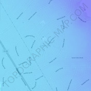
Name: Topografische Karte Salton City, Höhe, Relief.
Durchschnittliche Höhe: -40 m
Minimale Höhe: -70 m
Maximale Höhe: 1 m
Spenden
Rüste dich für dein nächstes Abenteuer:
Als Amazon-Partner verdient diese Website an qualifizierten Käufen, ohne zusätzliche Kosten für Sie.
Andere topografische Karten
Klicken Sie auf eine Karte, um ihre Topografie, ihre Höhe und ihr Relief anzuzeigen.
Brawley
United States > California > Imperial County
Brawley is located in the Colorado Desert and Lower Colorado River Valley regions. The city's elevation, like other Imperial Valley towns, is below sea level.
Durchschnittliche Höhe: -36 m
Spenden
Rüste dich für dein nächstes Abenteuer:
Als Amazon-Partner verdient diese Website an qualifizierten Käufen, ohne zusätzliche Kosten für Sie.
Calipatria
United States > California > Imperial County
At an elevation of 180 feet (55 m) below sea level, Calipatria is the lowest incorporated city in the Western Hemisphere. The city currently claims to have the "tallest flagpole (184 feet) where the flag flies at sea level" at 184 feet (56 m), so their American flag will always fly above sea level. According…
Durchschnittliche Höhe: -50 m
Bombay Beach
United States > California > Imperial County
The derelict "living ghost town" status of Bombay Beach has attracted many photographers, filmmakers, urban explorers, and tourists. The town, as well as others on the shores of the Salton Sea, is one of the lowest settlements in elevation in North America. The local American Legion, Post 801, had 36 members…
Durchschnittliche Höhe: -61 m
Spenden
Rüste dich für dein nächstes Abenteuer:
Als Amazon-Partner verdient diese Website an qualifizierten Käufen, ohne zusätzliche Kosten für Sie.
Calipatria
United States > California > Imperial County
At an elevation of 180 feet (55 m) below sea level, Calipatria is the lowest incorporated city in the Western Hemisphere. The city currently claims to have the "tallest flagpole (184 feet) where the flag flies at sea level" at 184 feet (56 m), so their American flag will always fly above sea level. According…
Durchschnittliche Höhe: -53 m
Spenden
Rüste dich für dein nächstes Abenteuer:
Als Amazon-Partner verdient diese Website an qualifizierten Käufen, ohne zusätzliche Kosten für Sie.