
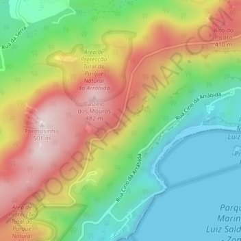
Topografische Karte Miradouro do Portinho da Arrábida
Interaktive Karte
Klicken Sie auf die Karte, um die Höhe anzuzeigen.
Über diese Karte
Name: Topografische Karte Miradouro do Portinho da Arrábida, Höhe, Relief.
Durchschnittliche Höhe: 208 m
Minimale Höhe: -2 m
Maximale Höhe: 487 m
Andere topografische Karten
Klicken Sie auf eine Karte, um ihre Topografie, ihre Höhe und ihr Relief anzuzeigen.
Azeitão (São Lourenço e São Simão)
Azeitão (São Lourenço e São Simão), Setúbal, Portugal
Durchschnittliche Höhe: 96 m
Formosinho
Formosinho, Setúbal, 2925-378, Portugal
Durchschnittliche Höhe: 244 m