
Topografische Karte Formosinho
Interaktive Karte
Klicken Sie auf die Karte, um die Höhe anzuzeigen.
Über diese Karte
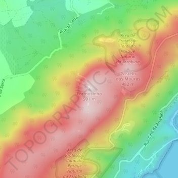
Name: Topografische Karte Formosinho, Höhe, Relief.
Ort: Formosinho, Setúbal, 2925-378, Portugal (38.48075 -9.00062 38.48085 -9.00052)
Durchschnittliche Höhe: 244 m
Minimale Höhe: 0 m
Maximale Höhe: 487 m
Andere topografische Karten
Klicken Sie auf eine Karte, um ihre Topografie, ihre Höhe und ihr Relief anzuzeigen.
Azeitão (São Lourenço e São Simão)
Azeitão (São Lourenço e São Simão), Setúbal, Portugal
Durchschnittliche Höhe: 96 m
Miradouro do Portinho da Arrábida
Miradouro do Portinho da Arrábida, EN 379-1, Fábrica Secil-Outão, Setúbal, Azeitão, Setúbal, 2925-378, Portugal
Durchschnittliche Höhe: 208 m