
Topografische Karte Maudlin
Interaktive Karte
Klicken Sie auf die Karte, um die Höhe anzuzeigen.
Über diese Karte
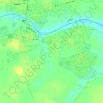
Name: Topografische Karte Maudlin, Höhe, Relief.
Durchschnittliche Höhe: 61 m
Minimale Höhe: 50 m
Maximale Höhe: 72 m
Andere topografische Karten
Klicken Sie auf eine Karte, um ihre Topografie, ihre Höhe und ihr Relief anzuzeigen.
Harlockstown
Harlockstown, Ratoath ED, The Municipal District of Ratoath, County Meath, Leinster, Ireland
Durchschnittliche Höhe: 73 m
Bettystown
Bettystown, The Municipal District of Laytown — Bettystown, County Meath, Leinster, A92 AH27, Ireland
Durchschnittliche Höhe: 6 m
Donore
Ireland > County Meath > Donore
Donore, The Municipal District of Laytown — Bettystown, County Meath, Leinster, A92 VW93, Ireland
Durchschnittliche Höhe: 57 m
The Municipal District of Laytown — Bettystown
The Municipal District of Laytown — Bettystown, County Meath, Leinster, Ireland
Durchschnittliche Höhe: 72 m
Boyne
Boyne, Kilcooly ED, The Municipal District of Trim, County Meath, Leinster, C15 X3Y2, Ireland
Durchschnittliche Höhe: 57 m
Kells
Ireland > County Meath > Kells
Kells, The Municipal District of Kells, County Meath, Leinster, A82 KD62, Ireland
Durchschnittliche Höhe: 70 m