
Topografische Karte Morichal Papunaua
Interaktive Karte
Klicken Sie auf die Karte, um die Höhe anzuzeigen.
Über diese Karte
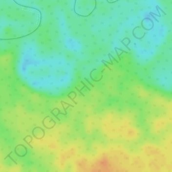
Name: Topografische Karte Morichal Papunaua, Höhe, Relief.
Ort: Morichal Papunaua, Vaupés, Colombia (1.90049 -70.61964 1.92049 -70.59964)
Durchschnittliche Höhe: 156 m
Minimale Höhe: 138 m
Maximale Höhe: 174 m
Andere topografische Karten
Klicken Sie auf eine Karte, um ihre Topografie, ihre Höhe und ihr Relief anzuzeigen.
Puerto Asis
Puerto Asis, Yavaraté, Vaupés, RAP Amazonía, Colombia
Durchschnittliche Höhe: 162 m
Acaricuara
Colombia > Vaupés > Mitú > Acaricuara
Acaricuara, Mitú, Vaupés, Colombia
Durchschnittliche Höhe: 170 m