
Topografische Karte Muara Enim
Interaktive Karte
Klicken Sie auf die Karte, um die Höhe anzuzeigen.
Über diese Karte
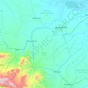
Name: Topografische Karte Muara Enim, Höhe, Relief.
Ort: Muara Enim, South Sumatra, Sumatra, Indonesia (-4.37709 103.31605 -3.01184 104.56449)
Durchschnittliche Höhe: 212 m
Minimale Höhe: 0 m
Maximale Höhe: 2.800 m
The resulting twenty-two districts (including the six now in the new Rambang Lubai Lematang Regency) are listed below with their areas and their populations at the 2010 Census and the 2020 Census, together with the official estimates as at mid 2022. The table also includes the locations of the district administrative centres, together with the number of villages in each district (comprising 245 rural desa and 10 urban kelurahan), and their post code(s). The topography of the regency comprised a southern group of five districts with an altitude of over 100 metres above sea level in the Bukit Barisan mountain chain, a west-central group of five districts, an east-central group of six districts (those split off in late 2022), and a northern group of six districts of mainly swamp area facing directly with the Musi River basin, which (since the creation of the Penukal Abab Lematang Ilir Regency in 2013) are physically separated from the rest of the Muara Enim Regency by the city of Prabumulih.
Andere topografische Karten
Klicken Sie auf eine Karte, um ihre Topografie, ihre Höhe und ihr Relief anzuzeigen.
Tanjung Enim
Indonesia > South Sumatra > Muara Enim
Tanjung Enim, Muara Enim, South Sumatra, Sumatra, Indonesia
Durchschnittliche Höhe: 76 m
Sungai Batu
Indonesia > South Sumatra > Banyuasin
Sungai Batu, Banyuasin II, Banyuasin, South Sumatra, Sumatra, Indonesia
Durchschnittliche Höhe: 10 m
Tungkal Jaya
Tungkal Jaya, Musi Banyuasin, South Sumatra, Sumatra, Indonesia
Durchschnittliche Höhe: 19 m
Musi Banyuasin
Musi Banyuasin, South Sumatra, Sumatra, 30711, Indonesia
Durchschnittliche Höhe: 29 m
Talang Akar
Indonesia > South Sumatra > Penukal Abab Lematang Ilir
Talang Akar, Talang Ubi, Penukal Abab Lematang Ilir, South Sumatra, Sumatra, Indonesia
Durchschnittliche Höhe: 45 m
Alai
Indonesia > South Sumatra > Muara Enim
Alai, Lembak, Muara Enim, South Sumatra, Indonesia
Durchschnittliche Höhe: 16 m
Napal
Indonesia > South Sumatra > Musi Banyuasin
Napal, Lawang Wetan, Musi Banyuasin, South Sumatra, Indonesia
Durchschnittliche Höhe: 17 m
Kemang
Indonesia > South Sumatra > Muara Enim
Kemang, Lembak, Muara Enim, South Sumatra, Sumatra, Indonesia
Durchschnittliche Höhe: 25 m
Rambutan
Indonesia > South Sumatra > Banyuasin
Rambutan, Banyuasin, South Sumatra, Indonesia
Durchschnittliche Höhe: 7 m
Air Solok Batu
Indonesia > South Sumatra > Banyuasin
Air Solok Batu, Air Salek, Banyuasin, South Sumatra, Indonesia
Durchschnittliche Höhe: 5 m
Gunung Agung
Indonesia > South Sumatra > Muara Enim > Gunung Agung
Gunung Agung, Semende Darat Tengah, Muara Enim, South Sumatra, Indonesia
Durchschnittliche Höhe: 1.464 m
Lesung Batu
Indonesia > South Sumatra > Muara Enim > Lesung Batu
Lesung Batu, Tanjung Agung, Muara Enim, South Sumatra, Indonesia
Durchschnittliche Höhe: 151 m
Betung
Indonesia > South Sumatra > Banyuasin > Betung
Betung, Banyuasin, South Sumatra, Indonesia
Durchschnittliche Höhe: 25 m
Alang Alang Lebar
Indonesia > South Sumatra > Palembang > Alang Alang Lebar
Alang Alang Lebar, Palembang, South Sumatra, 30154, Indonesia
Durchschnittliche Höhe: 11 m
Palembang
Palembang, South Sumatra, Sumatra, Indonesia
Durchschnittliche Höhe: 6 m
Indramayu
Indonesia > South Sumatra > Muara Enim
Indramayu, Tanjung Agung, Muara Enim, South Sumatra, Indonesia
Durchschnittliche Höhe: 328 m
Kebun Bunga
Indonesia > South Sumatra > Palembang > Kebun Bunga
Kebun Bunga, Sukarame, Palembang, South Sumatra, 30151, Indonesia
Durchschnittliche Höhe: 11 m
Sukarami
Indonesia > South Sumatra > Palembang > Sukarami
Sukarami, Sukarame, Palembang, South Sumatra, 30151, Indonesia
Durchschnittliche Höhe: 11 m
Sukarami
Indonesia > South Sumatra > Muara Enim
Sukarami, Sungai Rotan, Muara Enim, South Sumatra, Indonesia
Durchschnittliche Höhe: 9 m
Pagar Alam
Indonesia > South Sumatra > Pagar Alam
Pagar Alam, South Sumatra, Indonesia
Durchschnittliche Höhe: 1.293 m
Rt.53
Indonesia > South Sumatra > Rt.53
Rt.53, South Sumatra, 30114, Indonesia
Durchschnittliche Höhe: 10 m
Merapi
Indonesia > South Sumatra > Lahat > Merapi
Merapi, Merapi Timur, Lahat, South Sumatra, Indonesia
Durchschnittliche Höhe: 61 m