
Topografische Karte Ulverscroft
Klicken Sie auf die Karte, um die Höhe anzuzeigen.
Über diese Karte
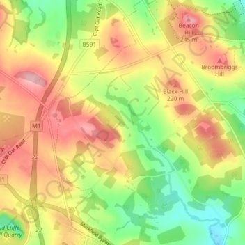
Name: Topografische Karte Ulverscroft, Höhe, Relief.
Durchschnittliche Höhe: 187 m
Minimale Höhe: 118 m
Maximale Höhe: 252 m
Andere topografische Karten
Klicken Sie auf eine Karte, um ihre Topografie, ihre Höhe und ihr Relief anzuzeigen.
Swithland Wood
United Kingdom > England > Leicestershire > Charnwood > Swithland
Durchschnittliche Höhe: 107 m
Bradgate Park
United Kingdom > England > Leicestershire > Charnwood > Newtown Linford
Overlying the Beacon Hill Formation, but found a little further down the hillside to the south, are the Bradgate Formation beds, the most notable of which is the Sliding Stone Slump Breccia rocks. Forming a line of crags below Old John, these are laminated mudstones, with layers of sandstone, mainly of…
Durchschnittliche Höhe: 126 m
Watermead Country Park
United Kingdom > England > Leicestershire > Charnwood > Birstall
Durchschnittliche Höhe: 59 m
Stanford Park
United Kingdom > England > Leicestershire > Charnwood > Hoton
Durchschnittliche Höhe: 69 m
Top Town Plantation
United Kingdom > England > Leicestershire > Charnwood > Walton on the Wolds
Durchschnittliche Höhe: 85 m
Moat Hill Spinney
United Kingdom > England > Leicestershire > Charnwood > Cotes
Durchschnittliche Höhe: 50 m
Lea Wood
United Kingdom > England > Leicestershire > Charnwood > Newtown Linford
Durchschnittliche Höhe: 170 m
Lower Moor
United Kingdom > England > Leicestershire > Charnwood > Cossington
Durchschnittliche Höhe: 53 m
Old John
United Kingdom > England > Leicestershire > Charnwood > Newtown Linford
Durchschnittliche Höhe: 143 m
Six Hills
United Kingdom > England > Leicestershire > Charnwood > Burton on the Wolds
Durchschnittliche Höhe: 128 m
Beacon Hill Country Park
United Kingdom > England > Leicestershire > Charnwood > Woodhouse Eaves
Durchschnittliche Höhe: 164 m