
Topografische Karte Tennessee
Interaktive Karte
Klicken Sie auf die Karte, um die Höhe anzuzeigen.
Über diese Karte
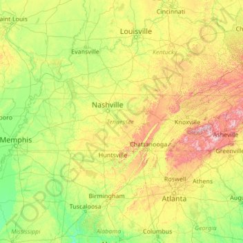
Name: Topografische Karte Tennessee, Höhe, Relief.
Ort: Tennessee, United States (34.98294 -90.31030 36.67812 -81.64722)
Durchschnittliche Höhe: 233 m
Minimale Höhe: 17 m
Maximale Höhe: 1.897 m
Tennessee has diverse terrain and landforms, and from east to west, contains a mix of cultural features characteristic of Appalachia, the Upland South, and the Deep South. The Blue Ridge Mountains along the eastern border reach some of the highest elevations in eastern North America, and the Cumberland Plateau contains many scenic valleys and waterfalls. The central part of the state is marked by cavernous bedrock and irregular rolling hills, and level, fertile plains define West Tennessee. The state is twice bisected by the Tennessee River, and the Mississippi River forms its western border. Its economy is dominated by the health care, music, finance, automotive, chemical, electronics, and tourism sectors, and cattle, soybeans, corn, poultry, and cotton are its primary agricultural products. The Great Smoky Mountains National Park, the nation's most visited national park, is in eastern Tennessee.
Andere topografische Karten
Klicken Sie auf eine Karte, um ihre Topografie, ihre Höhe und ihr Relief anzuzeigen.
Brooklyn
United States > New York > New York
Brooklyn, Kings County, New York, United States
Durchschnittliche Höhe: 9 m
Houston
United States > Texas > Harris County
Houston, Harris County, Texas, United States
Durchschnittliche Höhe: 25 m
Los Angeles
Los Angeles, California, United States
Durchschnittliche Höhe: 241 m
Albuquerque
United States > New Mexico > Bernalillo County
Albuquerque, Bernalillo County, New Mexico, United States
Durchschnittliche Höhe: 1.688 m
Boulder
United States > Colorado > Boulder County
Boulder, Boulder County, Colorado, United States
Durchschnittliche Höhe: 1.785 m
Des Moines
United States > Iowa > Polk County
Des Moines, Polk County, Iowa, United States
Durchschnittliche Höhe: 264 m
New Orleans
United States > Louisiana > Orleans Parish
New Orleans, Orleans Parish, Louisiana, United States
Durchschnittliche Höhe: 1 m
Santa Cruz
United States > California > Santa Cruz County
Santa Cruz, Santa Cruz County, California, United States
Durchschnittliche Höhe: 89 m
Arlington
United States > Massachusetts > Middlesex County
Arlington, Middlesex County, Massachusetts, United States
Durchschnittliche Höhe: 35 m
Baldwin County
Baldwin County, Alabama, United States
Durchschnittliche Höhe: 31 m
Amelia Island
United States > Florida > Nassau County > Fernandina Beach
Amelia Island, Fernandina Beach, Nassau County, Florida, 32034, United States
Durchschnittliche Höhe: 3 m
Salt Lake County
Salt Lake County, Utah, United States
Durchschnittliche Höhe: 1.811 m
Appalachian Mountains
United States > North Carolina > Yancey County
Appalachian Mountains, Yancey County, North Carolina, United States
Durchschnittliche Höhe: 1.463 m
Manhattan
United States > New York > New York County > New York
Manhattan, New York County, New York, United States
Durchschnittliche Höhe: 16 m
Brunswick County
United States > North Carolina
Brunswick County, North Carolina, United States
Durchschnittliche Höhe: 9 m
Fairfax County
Fairfax County, Virginia, United States
Durchschnittliche Höhe: 75 m
Bronx County
United States > New York > New York
Bronx County, The Bronx, New York, United States
Durchschnittliche Höhe: 21 m
Whatcom County
Whatcom County, Washington, United States
Durchschnittliche Höhe: 753 m
Irvine
United States > California > Orange County
Irvine, Orange County, California, United States
Durchschnittliche Höhe: 66 m
Kent County
Kent County, Michigan, United States
Durchschnittliche Höhe: 240 m
Yakima County
Yakima County, Washington, United States
Durchschnittliche Höhe: 879 m
Worcester
United States > Massachusetts > Worcester County
Worcester, Worcester County, Massachusetts, United States
Durchschnittliche Höhe: 186 m