
Topografische Karte Forsyth County
Interaktive Karte
Klicken Sie auf die Karte, um die Höhe anzuzeigen.
Über diese Karte
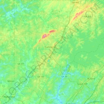
Name: Topografische Karte Forsyth County, Höhe, Relief.
Ort: Forsyth County, Georgia, USA (34.05071 -84.25893 34.33517 -83.92553)
Durchschnittliche Höhe: 344 m
Minimale Höhe: 274 m
Maximale Höhe: 577 m
Andere topografische Karten
Klicken Sie auf eine Karte, um ihre Topografie, ihre Höhe und ihr Relief anzuzeigen.
Stonecrest
USA > Georgia > Stonecrest
Stonecrest, DeKalb County, Georgia, USA
Durchschnittliche Höhe: 258 m
Stone Mountain
Stone Mountain, DeKalb County, Georgia, 30087, USA
Durchschnittliche Höhe: 299 m
Hidden Creek
Hidden Creek, Douglas County, Georgia, 30135, USA
Durchschnittliche Höhe: 286 m