
Topografische Karte Hidden Creek
Interaktive Karte
Klicken Sie auf die Karte, um die Höhe anzuzeigen.
Über diese Karte
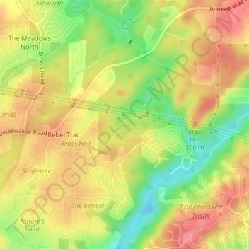
Name: Topografische Karte Hidden Creek, Höhe, Relief.
Ort: Hidden Creek, Douglas County, Georgia, 30135, USA (33.69104 -84.69187 33.69576 -84.68609)
Durchschnittliche Höhe: 286 m
Minimale Höhe: 237 m
Maximale Höhe: 322 m
Andere topografische Karten
Klicken Sie auf eine Karte, um ihre Topografie, ihre Höhe und ihr Relief anzuzeigen.
Stonecrest
USA > Georgia > Stonecrest
Stonecrest, DeKalb County, Georgia, USA
Durchschnittliche Höhe: 258 m
Stone Mountain
Stone Mountain, DeKalb County, Georgia, 30087, USA
Durchschnittliche Höhe: 299 m
Cameron Point
USA > Georgia > Cameron Point
Cameron Point, Hall County, Georgia, 30506:30534, USA
Durchschnittliche Höhe: 339 m