
Topografische Karte Wheeler County
Interaktive Karte
Klicken Sie auf die Karte, um die Höhe anzuzeigen.
Über diese Karte
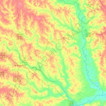
Name: Topografische Karte Wheeler County, Höhe, Relief.
Ort: Wheeler County, Georgia, USA (31.91919 -82.93991 32.30917 -82.53926)
Durchschnittliche Höhe: 62 m
Minimale Höhe: 22 m
Maximale Höhe: 108 m
Andere topografische Karten
Klicken Sie auf eine Karte, um ihre Topografie, ihre Höhe und ihr Relief anzuzeigen.
Stonecrest
USA > Georgia > Stonecrest
Stonecrest, DeKalb County, Georgia, USA
Durchschnittliche Höhe: 258 m
Stone Mountain
Stone Mountain, DeKalb County, Georgia, 30087, USA
Durchschnittliche Höhe: 299 m
Hidden Creek
Hidden Creek, Douglas County, Georgia, 30135, USA
Durchschnittliche Höhe: 286 m