
Topografische Karte Saint-Augustin-de-Woburn
Interaktive Karte
Klicken Sie auf die Karte, um die Höhe anzuzeigen.
Über diese Karte
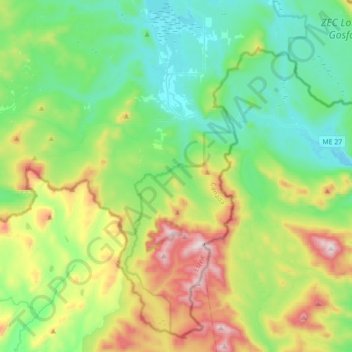
Name: Topografische Karte Saint-Augustin-de-Woburn, Höhe, Relief.
Durchschnittliche Höhe: 620 m
Minimale Höhe: 386 m
Maximale Höhe: 1.190 m
It is 5km from Canada–United States border and the Coburn Gore-Woburn Border Crossing. Mount Gosford lies entirely within the parish, making Woburn one of the highest towns in Quebec, at an altitude of 1,193 metres (3,914 ft).
Andere topografische Karten
Klicken Sie auf eine Karte, um ihre Topografie, ihre Höhe und ihr Relief anzuzeigen.
Val-Racine
Val-Racine, Le Granit, Estrie, Quebec, Canada
Durchschnittliche Höhe: 558 m
Montagne de Marbre
Canada > Quebec > Le Granit > Notre-Dame-des-Bois
Montagne de Marbre, Notre-Dame-des-Bois, Le Granit, Estrie, Quebec, Canada
Durchschnittliche Höhe: 713 m
Lac-Mégantic
Lac-Mégantic, Le Granit, Estrie, Quebec, Canada
Durchschnittliche Höhe: 434 m
Saint-Robert-Bellarmin
Canada > Quebec > Le Granit > Saint-Robert-Bellarmin
Saint-Robert-Bellarmin, Le Granit, Estrie, Quebec, Canada
Durchschnittliche Höhe: 466 m
Saint-Ludger
Saint-Ludger, Le Granit, Estrie, Quebec, G0M 1W0, Canada
Durchschnittliche Höhe: 451 m
Mont Gosford
Canada > Quebec > Le Granit > Saint-Augustin-de-Woburn
Mont Gosford, Saint-Augustin-de-Woburn, Le Granit, Estrie, Quebec, Canada
Durchschnittliche Höhe: 933 m