
Topografische Karte Milan
Interaktive Karte
Klicken Sie auf die Karte, um die Höhe anzuzeigen.
Über diese Karte
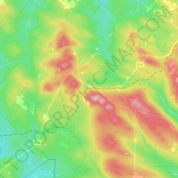
Name: Topografische Karte Milan, Höhe, Relief.
Ort: Milan, Le Granit, Estrie, Quebec, G0Y 1E0, Canada (45.52268 -71.23493 45.65535 -71.05177)
Durchschnittliche Höhe: 487 m
Minimale Höhe: 408 m
Maximale Höhe: 606 m
Andere topografische Karten
Klicken Sie auf eine Karte, um ihre Topografie, ihre Höhe und ihr Relief anzuzeigen.
Val-Racine
Val-Racine, Le Granit, Estrie, Quebec, Canada
Durchschnittliche Höhe: 558 m
Montagne de Marbre
Canada > Quebec > Le Granit > Notre-Dame-des-Bois
Montagne de Marbre, Notre-Dame-des-Bois, Le Granit, Estrie, Quebec, Canada
Durchschnittliche Höhe: 713 m
Saint-Augustin-de-Woburn
Saint-Augustin-de-Woburn, Le Granit, Estrie, Quebec, G0Y 1R0, Canada
Durchschnittliche Höhe: 620 m
Lac-Mégantic
Lac-Mégantic, Le Granit, Estrie, Quebec, Canada
Durchschnittliche Höhe: 434 m
Saint-Robert-Bellarmin
Canada > Quebec > Le Granit > Saint-Robert-Bellarmin
Saint-Robert-Bellarmin, Le Granit, Estrie, Quebec, Canada
Durchschnittliche Höhe: 466 m
Saint-Ludger
Saint-Ludger, Le Granit, Estrie, Quebec, G0M 1W0, Canada
Durchschnittliche Höhe: 451 m
Mont Gosford
Canada > Quebec > Le Granit > Saint-Augustin-de-Woburn
Mont Gosford, Saint-Augustin-de-Woburn, Le Granit, Estrie, Quebec, Canada
Durchschnittliche Höhe: 933 m