
Topografische Karte Puerres
Interaktive Karte
Klicken Sie auf die Karte, um die Höhe anzuzeigen.
Über diese Karte
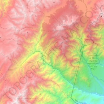
Name: Topografische Karte Puerres, Höhe, Relief.
Ort: Puerres, Ex-Providencia de Obando, Nariño, Colombia (0.67152 -77.54246 0.92810 -77.15916)
Durchschnittliche Höhe: 2.524 m
Minimale Höhe: 626 m
Maximale Höhe: 4.103 m
Andere topografische Karten
Klicken Sie auf eine Karte, um ihre Topografie, ihre Höhe und ihr Relief anzuzeigen.
San Bernardo
Colombia > Nariño > San Bernardo
San Bernardo, Rio Mayo, Nariño, Colombia
Durchschnittliche Höhe: 2.273 m
San Fransico (6)
Colombia > Nariño > Contadero > Vereda Yaez
San Fransico (6), Vereda Yaez, Contadero, Exprovincia de Obando, Nariño, RAP Pacífico, 523087, Colombia
Durchschnittliche Höhe: 2.804 m
Volcán Bordoncillo
Volcán Bordoncillo, Buesaco, Juanambú, Nariño, Colombia
Durchschnittliche Höhe: 3.515 m
Doña Juana
Colombia > Nariño > El Tablón de Gómez
Doña Juana, El Tablón de Gómez, Rio Mayo, Nariño, Colombia
Durchschnittliche Höhe: 3.733 m
Loma Puerta Del Paramo
Loma Puerta Del Paramo, Chachagüí, Centro, Nariño, Colombia
Durchschnittliche Höhe: 2.448 m
Morro El Gallo
Morro El Gallo, Pasto, Centro, Nariño, 0057, Colombia
Durchschnittliche Höhe: 3.133 m
Parque Parana
Parque Parana, Maridíaz, Pasto, Nariño, Colombia
Durchschnittliche Höhe: 2.553 m
Tangareal del Mira
Colombia > Nariño > Tangareal del Mira
Tangareal del Mira, Tumaco, Nariño, Colombia
Durchschnittliche Höhe: 14 m