
Topografische Karte Woodland Park
Interaktive Karte
Klicken Sie auf die Karte, um die Höhe anzuzeigen.
Über diese Karte
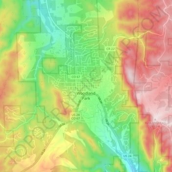
Name: Topografische Karte Woodland Park, Höhe, Relief.
Durchschnittliche Höhe: 2.652 m
Minimale Höhe: 2.445 m
Maximale Höhe: 2.884 m
The area is characterized by the abundance of large granite rocks and alpine meadows, as well as its consistently high elevation ranging between 8,200 and 10,000 feet above sea level. The climate is considered arid which causes the surrounding forests to become very dry, posing a significant fire threat in combination with a large proportion of lightning strikes and high mountain winds. Fire restrictions are common.
Andere topografische Karten
Klicken Sie auf eine Karte, um ihre Topografie, ihre Höhe und ihr Relief anzuzeigen.
Florissant Fossil Beds National Monument
United States > Colorado > Teller County
Florissant Fossil Beds National Monument, County Road 121, Teller County, Colorado, 80816, United States
Durchschnittliche Höhe: 2.616 m
Florissant
United States > Colorado > Teller County
Florissant, Teller County, Colorado, United States
Durchschnittliche Höhe: 2.556 m
Divide
United States > Colorado > Teller County
Divide, Teller County, Colorado, United States
Durchschnittliche Höhe: 2.796 m
Cripple Creek
United States > Colorado > Teller County
Cripple Creek, Teller County, Colorado, United States
Durchschnittliche Höhe: 2.946 m