
Topografische Karte Cripple Creek
Interaktive Karte
Klicken Sie auf die Karte, um die Höhe anzuzeigen.
Über diese Karte
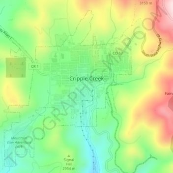
Name: Topografische Karte Cripple Creek, Höhe, Relief.
Ort: Cripple Creek, Teller County, Colorado, United States (38.73050 -105.20831 38.75981 -105.16776)
Durchschnittliche Höhe: 2.946 m
Minimale Höhe: 2.796 m
Maximale Höhe: 3.165 m
For many years, Cripple Creek's high valley, at an elevation of 9,494 feet (2,894 m), was considered no more important than a cattle pasture. Many prospectors avoided the area after the Mount Pisgah hoax, a mini gold rush caused by salting (adding gold to worthless rock).
Andere topografische Karten
Klicken Sie auf eine Karte, um ihre Topografie, ihre Höhe und ihr Relief anzuzeigen.
Florissant Fossil Beds National Monument
United States > Colorado > Teller County
Florissant Fossil Beds National Monument, County Road 121, Teller County, Colorado, 80816, United States
Durchschnittliche Höhe: 2.616 m
Florissant
United States > Colorado > Teller County
Florissant, Teller County, Colorado, United States
Durchschnittliche Höhe: 2.556 m
Divide
United States > Colorado > Teller County
Divide, Teller County, Colorado, United States
Durchschnittliche Höhe: 2.796 m
Woodland Park
United States > Colorado > Teller County
Woodland Park, Teller County, Colorado, 80863, United States
Durchschnittliche Höhe: 2.652 m