
Topografische Karte Florissant Fossil Beds National Monument
Interaktive Karte
Klicken Sie auf die Karte, um die Höhe anzuzeigen.
Über diese Karte
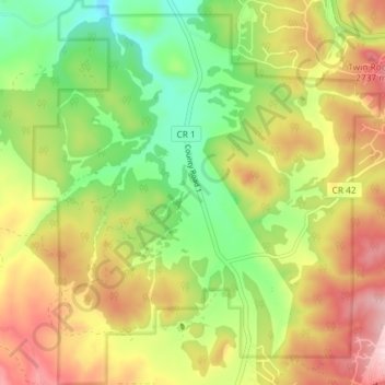
Name: Topografische Karte Florissant Fossil Beds National Monument, Höhe, Relief.
Durchschnittliche Höhe: 2.616 m
Minimale Höhe: 2.494 m
Maximale Höhe: 2.757 m
Early estimates of the elevation of the Florissant beds was determined to be between 300–900 meters, much lower than the modern elevation of 2,500-2,600 meters. However, more recent estimates that are based on paleoflora have put the elevation in the Eocene much higher. Ranges from 1,900 to 4,100 meters have been proposed. This would indicate that global climate change, rather than tectonic uplift, would be the main cause of changing environments in the area. The actual elevation of the Florissant area during the Eocene is still being determined. While most of the analysis using paleoflora has the area at a higher elevation than modern times, there is evidence that the elevation was as low as the earlier estimates.
Andere topografische Karten
Klicken Sie auf eine Karte, um ihre Topografie, ihre Höhe und ihr Relief anzuzeigen.
Florissant
United States > Colorado > Teller County
Florissant, Teller County, Colorado, United States
Durchschnittliche Höhe: 2.556 m
Divide
United States > Colorado > Teller County
Divide, Teller County, Colorado, United States
Durchschnittliche Höhe: 2.796 m
Cripple Creek
United States > Colorado > Teller County
Cripple Creek, Teller County, Colorado, United States
Durchschnittliche Höhe: 2.946 m
Woodland Park
United States > Colorado > Teller County
Woodland Park, Teller County, Colorado, 80863, United States
Durchschnittliche Höhe: 2.652 m