
Spenden
Rüste dich für dein nächstes Abenteuer:
Als Amazon-Partner verdient diese Website an qualifizierten Käufen, ohne zusätzliche Kosten für Sie.
Topografische Karte Mansfield
Klicken Sie auf die Karte, um die Höhe anzuzeigen.
Spenden
Rüste dich für dein nächstes Abenteuer:
Als Amazon-Partner verdient diese Website an qualifizierten Käufen, ohne zusätzliche Kosten für Sie.
Über diese Karte
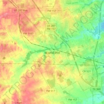
Name: Topografische Karte Mansfield, Höhe, Relief.
Ort: Mansfield, Tarrant County, Texas, 76063, United States (32.51209 -97.18674 32.61612 -97.04678)
Durchschnittliche Höhe: 195 m
Minimale Höhe: 160 m
Maximale Höhe: 231 m
Spenden
Rüste dich für dein nächstes Abenteuer:
Als Amazon-Partner verdient diese Website an qualifizierten Käufen, ohne zusätzliche Kosten für Sie.
Andere topografische Karten
Klicken Sie auf eine Karte, um ihre Topografie, ihre Höhe und ihr Relief anzuzeigen.
Spenden
Rüste dich für dein nächstes Abenteuer:
Als Amazon-Partner verdient diese Website an qualifizierten Käufen, ohne zusätzliche Kosten für Sie.
Eagle Mountain Lake
United States > Texas > Tarrant County > Pelican Bay
Durchschnittliche Höhe: 228 m
Spenden
Rüste dich für dein nächstes Abenteuer:
Als Amazon-Partner verdient diese Website an qualifizierten Käufen, ohne zusätzliche Kosten für Sie.
Grapevine
United States > Texas > Tarrant County > Grapevine > Grapevine
Durchschnittliche Höhe: 181 m
Southlake
United States > Texas > Tarrant County > Southlake > Southlake
Durchschnittliche Höhe: 190 m
Spenden
Rüste dich für dein nächstes Abenteuer:
Als Amazon-Partner verdient diese Website an qualifizierten Käufen, ohne zusätzliche Kosten für Sie.
Spenden
Rüste dich für dein nächstes Abenteuer:
Als Amazon-Partner verdient diese Website an qualifizierten Käufen, ohne zusätzliche Kosten für Sie.
Benbrook Lake
United States > Texas > Tarrant County > Fort Worth
Construction of Benbrook dam began in May 1947, and was practically completed when floodgates were closed and deliberate impoundment was begun in September 1952. The cost to build the lake was $14.5 million ($112 million in 2007 dollars). The rolled-earth embankment is 9,130 feet (2,783 m) in length, including…
Durchschnittliche Höhe: 230 m
Spenden
Rüste dich für dein nächstes Abenteuer:
Als Amazon-Partner verdient diese Website an qualifizierten Käufen, ohne zusätzliche Kosten für Sie.
La Frontera
United States > Texas > Tarrant County > Arlington > La Frontera
Durchschnittliche Höhe: 185 m
Spenden
Rüste dich für dein nächstes Abenteuer:
Als Amazon-Partner verdient diese Website an qualifizierten Käufen, ohne zusätzliche Kosten für Sie.