
Topografische Karte Alta
Interaktive Karte
Klicken Sie auf die Karte, um die Höhe anzuzeigen.
Über diese Karte
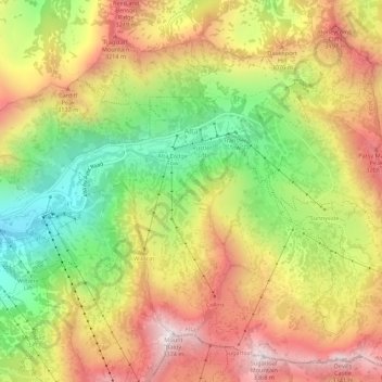
Name: Topografische Karte Alta, Höhe, Relief.
Ort: Alta, Salt Lake County, Utah, United States (40.56441 -111.65273 40.60326 -111.59808)
Durchschnittliche Höhe: 2.912 m
Minimale Höhe: 2.437 m
Maximale Höhe: 3.369 m
Alta experiences a high altitude humid continental climate (Köppen Dfb), which borders on a subalpine climate (Dfc), due to its high elevation. Due to its proximity to the Great Salt Lake, the town receives very heavy snows, averaging over 507 inches (12.9 m) per year. During the very wet season of 1982/1983, Alta received as much as 900 inches (23 m) of snow, leading to record flooding of Wasatch streams as the snow melted during May and June that year. Alta's total precipitation of 108.54 inches (2,756.9 mm) during 1983 is a record for a calendar year in any state of the Mountain West;.
Andere topografische Karten
Klicken Sie auf eine Karte, um ihre Topografie, ihre Höhe und ihr Relief anzuzeigen.
Taylorsville
United States > Utah > Salt Lake County
Taylorsville, Salt Lake County, Utah, United States
Durchschnittliche Höhe: 1.325 m
Draper Commercial Parkway
United States > Utah > Salt Lake County > Draper
Draper Commercial Parkway, Draper, Salt Lake County, Utah, 84020, United States
Durchschnittliche Höhe: 1.355 m
Magna
United States > Utah > Salt Lake County
Magna, Salt Lake County, Utah, United States
Durchschnittliche Höhe: 1.341 m
Bellwood Acres
United States > Utah > Salt Lake County > Cottonwood Heights
Bellwood Acres, Cottonwood Heights, Salt Lake County, Utah, 84121, United States
Durchschnittliche Höhe: 1.398 m
Sprucewood
United States > Utah > Salt Lake County > Sandy
Sprucewood, Sandy, Salt Lake County, Utah, 84094, United States
Durchschnittliche Höhe: 1.418 m
West Valley City
United States > Utah > Salt Lake County
West Valley City, Salt Lake County, Utah, United States
Durchschnittliche Höhe: 1.351 m
Brighton
United States > Utah > Salt Lake County
Brighton, Salt Lake County, Utah, United States
Durchschnittliche Höhe: 2.852 m
West Jordan
United States > Utah > Salt Lake County
West Jordan, Salt Lake County, Utah, United States
Durchschnittliche Höhe: 1.372 m
Midvale
United States > Utah > Salt Lake County
Midvale, Salt Lake County, Utah, 84047, United States
Durchschnittliche Höhe: 1.331 m
Salt Lake City
United States > Utah > Salt Lake County
Salt Lake City, Salt Lake County, Utah, United States
Durchschnittliche Höhe: 1.592 m
Salt Lake City
United States > Utah > Salt Lake County > Salt Lake City
Salt Lake City, Salt Lake County, Utah, 84139, United States
Durchschnittliche Höhe: 1.625 m
Sandy
United States > Utah > Salt Lake County
Sandy, Salt Lake County, Utah, United States
Durchschnittliche Höhe: 1.376 m
Hillborough Heights
United States > Utah > Salt Lake County > Sandy > Hillborough Heights
Hillborough Heights, Sandy, Salt Lake County, Utah, 84093, United States
Durchschnittliche Höhe: 1.501 m
South Valence Drainage
United States > Utah > Salt Lake County > West Jordan
South Valence Drainage, West Jordan, Salt Lake County, Utah, United States
Durchschnittliche Höhe: 1.388 m
Millcreek
United States > Utah > Salt Lake County > Millcreek
Millcreek, Salt Lake County, Utah, 84106, United States
Durchschnittliche Höhe: 1.715 m
South Jordan
United States > Utah > Salt Lake County > South Jordan
South Jordan, Salt Lake County, Utah, United States
Durchschnittliche Höhe: 1.384 m
Snowbird
United States > Utah > Salt Lake County
Snowbird, Salt Lake County, Utah, 85092, United States
Durchschnittliche Höhe: 2.760 m
Draper
United States > Utah > Salt Lake County
Draper, Salt Lake County, Utah, 84020, United States
Durchschnittliche Höhe: 1.573 m