
Topografische Karte West Jordan
Interaktive Karte
Klicken Sie auf die Karte, um die Höhe anzuzeigen.
Über diese Karte
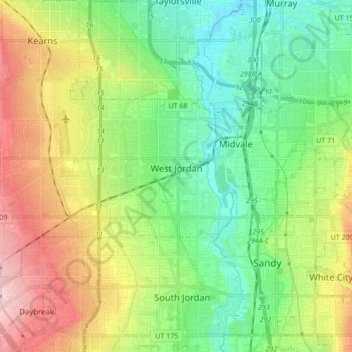
Name: Topografische Karte West Jordan, Höhe, Relief.
Ort: West Jordan, Salt Lake County, Utah, United States (40.56594 -112.08259 40.64014 -111.91174)
Durchschnittliche Höhe: 1.372 m
Minimale Höhe: 1.296 m
Maximale Höhe: 1.507 m
West Jordan is a city in Salt Lake County, Utah, United States. It is a suburb of Salt Lake City and has a mixed economy. According to the 2020 Census, the city had a population of 116,961, placing it as the third most populous in the state. The city occupies the southwest end of the Salt Lake Valley at an elevation of 4,330 feet (1,320 m). Named after the nearby Jordan River, the limits of the city begin on the river's western bank and end in the eastern foothills of the Oquirrh Mountains, where Kennecott Copper Mine, the world's largest man-made excavation, is located.
Andere topografische Karten
Klicken Sie auf eine Karte, um ihre Topografie, ihre Höhe und ihr Relief anzuzeigen.
Taylorsville
United States > Utah > Salt Lake County
Taylorsville, Salt Lake County, Utah, United States
Durchschnittliche Höhe: 1.325 m
Draper Commercial Parkway
United States > Utah > Salt Lake County > Draper
Draper Commercial Parkway, Draper, Salt Lake County, Utah, 84020, United States
Durchschnittliche Höhe: 1.355 m
Magna
United States > Utah > Salt Lake County
Magna, Salt Lake County, Utah, United States
Durchschnittliche Höhe: 1.341 m
Bellwood Acres
United States > Utah > Salt Lake County > Cottonwood Heights
Bellwood Acres, Cottonwood Heights, Salt Lake County, Utah, 84121, United States
Durchschnittliche Höhe: 1.398 m
Sprucewood
United States > Utah > Salt Lake County > Sandy
Sprucewood, Sandy, Salt Lake County, Utah, 84094, United States
Durchschnittliche Höhe: 1.418 m
West Valley City
United States > Utah > Salt Lake County
West Valley City, Salt Lake County, Utah, United States
Durchschnittliche Höhe: 1.351 m
Alta
United States > Utah > Salt Lake County
Alta, Salt Lake County, Utah, United States
Durchschnittliche Höhe: 2.912 m
Brighton
United States > Utah > Salt Lake County
Brighton, Salt Lake County, Utah, United States
Durchschnittliche Höhe: 2.852 m
Midvale
United States > Utah > Salt Lake County
Midvale, Salt Lake County, Utah, 84047, United States
Durchschnittliche Höhe: 1.331 m
Salt Lake City
United States > Utah > Salt Lake County
Salt Lake City, Salt Lake County, Utah, United States
Durchschnittliche Höhe: 1.592 m
Salt Lake City
United States > Utah > Salt Lake County > Salt Lake City
Salt Lake City, Salt Lake County, Utah, 84139, United States
Durchschnittliche Höhe: 1.625 m
Sandy
United States > Utah > Salt Lake County
Sandy, Salt Lake County, Utah, United States
Durchschnittliche Höhe: 1.376 m
Hillborough Heights
United States > Utah > Salt Lake County > Sandy > Hillborough Heights
Hillborough Heights, Sandy, Salt Lake County, Utah, 84093, United States
Durchschnittliche Höhe: 1.501 m
South Valence Drainage
United States > Utah > Salt Lake County > West Jordan
South Valence Drainage, West Jordan, Salt Lake County, Utah, United States
Durchschnittliche Höhe: 1.388 m
Millcreek
United States > Utah > Salt Lake County > Millcreek
Millcreek, Salt Lake County, Utah, 84106, United States
Durchschnittliche Höhe: 1.715 m
South Jordan
United States > Utah > Salt Lake County > South Jordan
South Jordan, Salt Lake County, Utah, United States
Durchschnittliche Höhe: 1.384 m
Snowbird
United States > Utah > Salt Lake County
Snowbird, Salt Lake County, Utah, 85092, United States
Durchschnittliche Höhe: 2.760 m
Draper
United States > Utah > Salt Lake County
Draper, Salt Lake County, Utah, 84020, United States
Durchschnittliche Höhe: 1.573 m