
Topografische Karte Fairhope
Interaktive Karte
Klicken Sie auf die Karte, um die Höhe anzuzeigen.
Über diese Karte
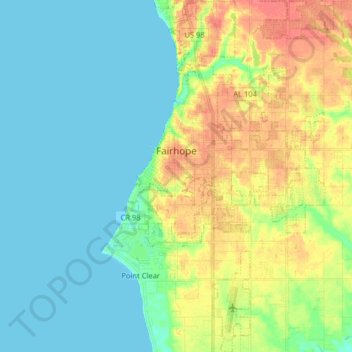
Name: Topografische Karte Fairhope, Höhe, Relief.
Ort: Fairhope, Baldwin County, Alabama, 36533, United States (30.44445 -87.92550 30.58229 -87.83541)
Durchschnittliche Höhe: 17 m
Minimale Höhe: 0 m
Maximale Höhe: 49 m
According to the U.S. Census Bureau, the city has a total area of 12.0 square miles (31.1 km2), of which 0.019 square mile (0.05 km2), or 0.16%, is water. Its elevation ranges from sea level at the bay to 122 feet (37 m) in the city center.
Andere topografische Karten
Klicken Sie auf eine Karte, um ihre Topografie, ihre Höhe und ihr Relief anzuzeigen.
Fort McDermott
United States > Alabama > Baldwin County > Spanish Fort
Fort McDermott, Spanish Fort, Baldwin County, Alabama, 36527, United States
Durchschnittliche Höhe: 18 m
Daphne
United States > Alabama > Baldwin County
Daphne, Baldwin County, Alabama, 36526, United States
Durchschnittliche Höhe: 25 m
Bridgehead
United States > Alabama > Baldwin County > Spanish Fort
Bridgehead, Spanish Fort, Baldwin County, Alabama, 36527, United States
Durchschnittliche Höhe: 22 m
Gulf Shores
United States > Alabama > Baldwin County
Gulf Shores, Baldwin County, Alabama, 36542, United States
Durchschnittliche Höhe: 4 m
Foley
United States > Alabama > Baldwin County
Foley, Baldwin County, Alabama, 36535, United States
Durchschnittliche Höhe: 20 m
Orange Beach
United States > Alabama > Baldwin County
Orange Beach, Baldwin County, Alabama, United States
Durchschnittliche Höhe: 5 m