
Topografische Karte Gulf Shores
Interaktive Karte
Klicken Sie auf die Karte, um die Höhe anzuzeigen.
Über diese Karte
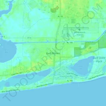
Name: Topografische Karte Gulf Shores, Höhe, Relief.
Ort: Gulf Shores, Baldwin County, Alabama, 36542, United States (30.23112 -87.72938 30.31112 -87.64938)
Durchschnittliche Höhe: 4 m
Minimale Höhe: -3 m
Maximale Höhe: 18 m
Andere topografische Karten
Klicken Sie auf eine Karte, um ihre Topografie, ihre Höhe und ihr Relief anzuzeigen.
Fort McDermott
United States > Alabama > Baldwin County > Spanish Fort
Fort McDermott, Spanish Fort, Baldwin County, Alabama, 36527, United States
Durchschnittliche Höhe: 18 m
Daphne
United States > Alabama > Baldwin County
Daphne, Baldwin County, Alabama, 36526, United States
Durchschnittliche Höhe: 25 m
Fairhope
United States > Alabama > Baldwin County
Fairhope, Baldwin County, Alabama, 36533, United States
Durchschnittliche Höhe: 17 m
Bridgehead
United States > Alabama > Baldwin County > Spanish Fort
Bridgehead, Spanish Fort, Baldwin County, Alabama, 36527, United States
Durchschnittliche Höhe: 22 m
Foley
United States > Alabama > Baldwin County
Foley, Baldwin County, Alabama, 36535, United States
Durchschnittliche Höhe: 20 m
Orange Beach
United States > Alabama > Baldwin County
Orange Beach, Baldwin County, Alabama, United States
Durchschnittliche Höhe: 5 m