
Topografische Karte Daphne
Interaktive Karte
Klicken Sie auf die Karte, um die Höhe anzuzeigen.
Über diese Karte
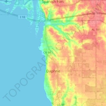
Name: Topografische Karte Daphne, Höhe, Relief.
Ort: Daphne, Baldwin County, Alabama, 36526, United States (30.56903 -87.92237 30.67677 -87.84305)
Durchschnittliche Höhe: 25 m
Minimale Höhe: -2 m
Maximale Höhe: 65 m
The topography of Daphne is quite consistent from a gently sloping sea level on the west to low rolling hills further east. Generally, the entire city lies no more than 150 feet above sea level. The land along the Daphne bay coast, like other land throughout the county, is rich with sandy-loam type soils.
Andere topografische Karten
Klicken Sie auf eine Karte, um ihre Topografie, ihre Höhe und ihr Relief anzuzeigen.
Fort McDermott
United States > Alabama > Baldwin County > Spanish Fort
Fort McDermott, Spanish Fort, Baldwin County, Alabama, 36527, United States
Durchschnittliche Höhe: 18 m
Fairhope
United States > Alabama > Baldwin County
Fairhope, Baldwin County, Alabama, 36533, United States
Durchschnittliche Höhe: 17 m
Bridgehead
United States > Alabama > Baldwin County > Spanish Fort
Bridgehead, Spanish Fort, Baldwin County, Alabama, 36527, United States
Durchschnittliche Höhe: 22 m
Gulf Shores
United States > Alabama > Baldwin County
Gulf Shores, Baldwin County, Alabama, 36542, United States
Durchschnittliche Höhe: 4 m
Foley
United States > Alabama > Baldwin County
Foley, Baldwin County, Alabama, 36535, United States
Durchschnittliche Höhe: 20 m
Orange Beach
United States > Alabama > Baldwin County
Orange Beach, Baldwin County, Alabama, United States
Durchschnittliche Höhe: 5 m