
Topografische Karte Lindi Region
Interaktive Karte
Klicken Sie auf die Karte, um die Höhe anzuzeigen.
Über diese Karte
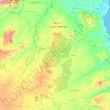
Name: Topografische Karte Lindi Region, Höhe, Relief.
Ort: Lindi Region, Coastal Zone, Tanzania (-10.73757 36.86896 -7.93453 39.98170)
Durchschnittliche Höhe: 402 m
Minimale Höhe: 0 m
Maximale Höhe: 2.228 m
The region is divided into two main agro-ecological zones; the coastal zone which is the main cultivation of tree crops such as cashew, coconut and mango. These areas are Lindi and Kilwa districts respectively with an elevation of 0 to 400 meters. Roughly 10% of farmers commercially grow cashews for export. The second agro-ecological zone is the midlands where the main cultivation of crops include maize, African rice, sesame and cassava. These areas are mostly Liwale and Nachingwea districts with an elevation of 300 to 900 meters above sea level. Rearing of livestock is still low in Lindi compared to other regions.
Andere topografische Karten
Klicken Sie auf eine Karte, um ihre Topografie, ihre Höhe und ihr Relief anzuzeigen.
Makunduchi
Tanzania > Zanzibar South & Central
Makunduchi, Kusini, Zanzibar South & Central, Zanzibar, 72103, Tanzania
Durchschnittliche Höhe: 17 m
Isapula
Isapula, Makete, Njombe Region, Southern Highlands Zone, Tanzania
Durchschnittliche Höhe: 2.229 m
Dodoma
Dodoma, Dodoma City, Dodoma Region, Central Zone, Tanzania
Durchschnittliche Höhe: 1.144 m
Ngorongoro
Ngorongoro, Arusha, Northern Zone, Tanzania
Durchschnittliche Höhe: 1.481 m
Iwafi
Iwafi, Njombe, Njombe Region, Southern Highlands Zone, Tanzania
Durchschnittliche Höhe: 1.600 m
Lupembe
Lupembe, Njombe, Njombe Region, Southern Highlands Zone, Tanzania
Durchschnittliche Höhe: 1.574 m
Njombe Region
Njombe Region, Southern Highlands Zone, Tanzania
Durchschnittliche Höhe: 1.317 m
Madudu
Madudu, Kilosa, Morogoro Region, Coastal Zone, Tanzania
Durchschnittliche Höhe: 450 m
Maleuts
Maleuts, Makete, Njombe Region, Southern Highlands Zone, Tanzania
Durchschnittliche Höhe: 2.204 m
Kilimanjaro National Park
Tanzania > Kilimanjaro > Moshi
Kilimanjaro National Park, Barranco Wall, Moshi, Hai, Kilimanjaro, Northern Zone, Tanzania
Durchschnittliche Höhe: 2.137 m
Sumbawanga
Sumbawanga, Sumbawanga Urban, Rukwa Region, Southern Highlands Zone, Tanzania
Durchschnittliche Höhe: 1.844 m
Moshi
Tanzania > Kilimanjaro > Moshi
Moshi, Hai, Kilimanjaro, Northern Zone, 25107, Tanzania
Durchschnittliche Höhe: 1.109 m
Waranga
Waranga, Hanang, Manyara Region, Northern Zone, Tanzania
Durchschnittliche Höhe: 1.448 m
Songwe Region
Songwe Region, Southern Highlands Zone, Tanzania
Durchschnittliche Höhe: 1.326 m
Mount Meru
Mount Meru, Arusha, Northern Zone, Tanzania
Durchschnittliche Höhe: 3.885 m
Kitongoji cha Makanisani
Tanzania > Simiyu > Lamadi > Kitongoji cha Makanisani
Kitongoji cha Makanisani, Lamadi, Busega, Simiyu, Lake Zone, Tanzania
Durchschnittliche Höhe: 1.140 m
Serengeti National Park
Serengeti National Park, Ikoma, Serengeti, Mara Region, Lake Zone, Tanzania
Durchschnittliche Höhe: 1.524 m
Oysterbay
Oysterbay, Msasani, Dar es Salaam, Coastal Zone, Tanzania
Durchschnittliche Höhe: 6 m
Kinondoni
Kinondoni, Dar es Salaam, Coastal Zone, 14110, Tanzania
Durchschnittliche Höhe: 12 m
Kilombero
Tanzania > Zanzibar North > Kilombero
Kilombero, Zanzibar North, Zanzibar, Tanzania
Durchschnittliche Höhe: 54 m
Kidayi 'A'
Tanzania > Morogoro > Kidayi 'A'
Kidayi 'A', Kilosa, Morogoro, Coastal Zone, Tanzania
Durchschnittliche Höhe: 659 m
Tarangire National Park
Tarangire National Park, Ridge Road, Babati, Manyara, Northern Zone, Tanzania
Durchschnittliche Höhe: 1.252 m