
Spenden
Rüste dich für dein nächstes Abenteuer:
Als Amazon-Partner verdient diese Website an qualifizierten Käufen, ohne zusätzliche Kosten für Sie.
Topografische Karte Letchworth
Klicken Sie auf die Karte, um die Höhe anzuzeigen.
Spenden
Rüste dich für dein nächstes Abenteuer:
Als Amazon-Partner verdient diese Website an qualifizierten Käufen, ohne zusätzliche Kosten für Sie.
Über diese Karte
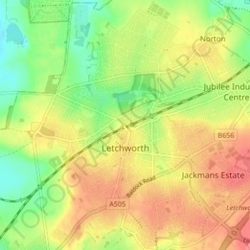
Name: Topografische Karte Letchworth, Höhe, Relief.
Ort: Letchworth, Hertfordshire, England, United Kingdom (51.96105 -0.25510 51.99937 -0.19579)
Durchschnittliche Höhe: 81 m
Minimale Höhe: 48 m
Maximale Höhe: 111 m
Spenden
Rüste dich für dein nächstes Abenteuer:
Als Amazon-Partner verdient diese Website an qualifizierten Käufen, ohne zusätzliche Kosten für Sie.
Andere topografische Karten
Klicken Sie auf eine Karte, um ihre Topografie, ihre Höhe und ihr Relief anzuzeigen.
St Albans
United Kingdom > England > Hertfordshire
The borough consisted of the ancient parish of St Albans (also known as the Abbey parish) and parts of the parishes of St Michael and St Peter. The borough was reformed by the Municipal Corporations Act 1835 to become a municipal borough, and the boundary was adjusted to additionally include part of the parish…
Durchschnittliche Höhe: 103 m
Burnham Green
United Kingdom > England > Hertfordshire > East Hertfordshire
Durchschnittliche Höhe: 102 m
Spenden
Rüste dich für dein nächstes Abenteuer:
Als Amazon-Partner verdient diese Website an qualifizierten Käufen, ohne zusätzliche Kosten für Sie.
Spellbrook
United Kingdom > England > Hertfordshire > East Hertfordshire > Sawbridgeworth
Durchschnittliche Höhe: 71 m
Spenden
Rüste dich für dein nächstes Abenteuer:
Als Amazon-Partner verdient diese Website an qualifizierten Käufen, ohne zusätzliche Kosten für Sie.
Little Amwell
United Kingdom > England > Hertfordshire > East Hertfordshire
Durchschnittliche Höhe: 65 m
Broken Green
United Kingdom > England > Hertfordshire > East Hertfordshire
Durchschnittliche Höhe: 97 m
Spenden
Rüste dich für dein nächstes Abenteuer:
Als Amazon-Partner verdient diese Website an qualifizierten Käufen, ohne zusätzliche Kosten für Sie.
St Ippolyts
United Kingdom > England > Hertfordshire > North Hertfordshire
Durchschnittliche Höhe: 103 m
Hertingfordbury
United Kingdom > England > Hertfordshire > East Hertfordshire
Durchschnittliche Höhe: 61 m
Spenden
Rüste dich für dein nächstes Abenteuer:
Als Amazon-Partner verdient diese Website an qualifizierten Käufen, ohne zusätzliche Kosten für Sie.
Welwyn Garden City
United Kingdom > England > Hertfordshire > Welwyn Hatfield
Durchschnittliche Höhe: 89 m
Spenden
Rüste dich für dein nächstes Abenteuer:
Als Amazon-Partner verdient diese Website an qualifizierten Käufen, ohne zusätzliche Kosten für Sie.
Letchworth
United Kingdom > England > Hertfordshire > North Hertfordshire > Letchworth
Durchschnittliche Höhe: 80 m
Spenden
Rüste dich für dein nächstes Abenteuer:
Als Amazon-Partner verdient diese Website an qualifizierten Käufen, ohne zusätzliche Kosten für Sie.
Croxley Green
United Kingdom > England > Hertfordshire > Three Rivers > Rickmansworth
Durchschnittliche Höhe: 67 m
Spenden
Rüste dich für dein nächstes Abenteuer:
Als Amazon-Partner verdient diese Website an qualifizierten Käufen, ohne zusätzliche Kosten für Sie.
Sarratt
United Kingdom > England > Hertfordshire > Three Rivers > Sarratt
Durchschnittliche Höhe: 107 m
Spenden
Rüste dich für dein nächstes Abenteuer:
Als Amazon-Partner verdient diese Website an qualifizierten Käufen, ohne zusätzliche Kosten für Sie.
Ashbrook
United Kingdom > England > Hertfordshire > North Hertfordshire > St Ippolyts
Durchschnittliche Höhe: 85 m
Perry Green
United Kingdom > England > Hertfordshire > East Hertfordshire
Durchschnittliche Höhe: 78 m
Spenden
Rüste dich für dein nächstes Abenteuer:
Als Amazon-Partner verdient diese Website an qualifizierten Käufen, ohne zusätzliche Kosten für Sie.
St Albans
United Kingdom > England > Hertfordshire
St Albans was an ancient borough created following the dissolution of the monastery in 1539. It consisted of the ancient parish of St Albans (also known as the Abbey parish) and parts of St Michael and St Peter. The municipal corporation was reformed by the Municipal Corporations Act 1835 and the boundary was…
Durchschnittliche Höhe: 107 m
Spenden
Rüste dich für dein nächstes Abenteuer:
Als Amazon-Partner verdient diese Website an qualifizierten Käufen, ohne zusätzliche Kosten für Sie.
Harpenden
United Kingdom > England > Hertfordshire > St Albans > Hatching Green
Durchschnittliche Höhe: 119 m
Knebworth
United Kingdom > England > Hertfordshire > North Hertfordshire
Durchschnittliche Höhe: 103 m
Spenden
Rüste dich für dein nächstes Abenteuer:
Als Amazon-Partner verdient diese Website an qualifizierten Käufen, ohne zusätzliche Kosten für Sie.
Bishop's Stortford
United Kingdom > England > Hertfordshire > East Hertfordshire
Stortford, along with the rest of Britain, has a temperate maritime climate, with cool summers and mild winters. The nearest weather station for which averages and extremes are available is Stansted Airport, about 2+1⁄2 miles (4 kilometres) due east of Stortford's town centre. Located at an elevation of over…
Durchschnittliche Höhe: 83 m
Spenden
Rüste dich für dein nächstes Abenteuer:
Als Amazon-Partner verdient diese Website an qualifizierten Käufen, ohne zusätzliche Kosten für Sie.
Berkhamsted
United Kingdom > England > Hertfordshire > Dacorum
The layout of Berkhamsted's centre is typical of a medieval market settlement: the linear High Street (aligned on the Akeman Street) forms the spine of the town (roughly aligned east–west), from which extend medieval burgage plots (to the north and south). The surviving burgage plot layout is the result of a…
Durchschnittliche Höhe: 142 m
Spenden
Rüste dich für dein nächstes Abenteuer:
Als Amazon-Partner verdient diese Website an qualifizierten Käufen, ohne zusätzliche Kosten für Sie.
Spenden
Rüste dich für dein nächstes Abenteuer:
Als Amazon-Partner verdient diese Website an qualifizierten Käufen, ohne zusätzliche Kosten für Sie.
Primrosehill
United Kingdom > England > Hertfordshire > Three Rivers > Abbots Langley
Durchschnittliche Höhe: 111 m
Throcking
United Kingdom > England > Hertfordshire > East Hertfordshire > Buntingford
Durchschnittliche Höhe: 126 m
Spenden
Rüste dich für dein nächstes Abenteuer:
Als Amazon-Partner verdient diese Website an qualifizierten Käufen, ohne zusätzliche Kosten für Sie.
Hammerfield
United Kingdom > England > Hertfordshire > Dacorum > Hemel Hempstead
Durchschnittliche Höhe: 122 m
Temple Dinsley
United Kingdom > England > Hertfordshire > North Hertfordshire > Preston
Durchschnittliche Höhe: 124 m
Spenden
Rüste dich für dein nächstes Abenteuer:
Als Amazon-Partner verdient diese Website an qualifizierten Käufen, ohne zusätzliche Kosten für Sie.
Bendish
United Kingdom > England > Hertfordshire > North Hertfordshire > Breachwood Green
Durchschnittliche Höhe: 128 m
Blackmore End
United Kingdom > England > Hertfordshire > St Albans > Wheathampstead
Durchschnittliche Höhe: 114 m
Tewin Wood
United Kingdom > England > Hertfordshire > East Hertfordshire > Burnham Green
Durchschnittliche Höhe: 101 m
Spenden
Rüste dich für dein nächstes Abenteuer:
Als Amazon-Partner verdient diese Website an qualifizierten Käufen, ohne zusätzliche Kosten für Sie.
Ayot St Peter
United Kingdom > England > Hertfordshire > Welwyn Hatfield
Durchschnittliche Höhe: 103 m
Northchurch
United Kingdom > England > Hertfordshire > Dacorum > Northchurch
Durchschnittliche Höhe: 162 m
Aston
United Kingdom > England > Hertfordshire > East Hertfordshire > Aston
Durchschnittliche Höhe: 99 m
Spenden
Rüste dich für dein nächstes Abenteuer:
Als Amazon-Partner verdient diese Website an qualifizierten Käufen, ohne zusätzliche Kosten für Sie.
Great Ashby
United Kingdom > England > Hertfordshire > North Hertfordshire
Durchschnittliche Höhe: 134 m
Amwell
United Kingdom > England > Hertfordshire > St Albans > Wheathampstead
Durchschnittliche Höhe: 106 m
Moorend
United Kingdom > England > Hertfordshire > Dacorum > Corner Hall
Durchschnittliche Höhe: 121 m
Spenden
Rüste dich für dein nächstes Abenteuer:
Als Amazon-Partner verdient diese Website an qualifizierten Käufen, ohne zusätzliche Kosten für Sie.
King's Meads
United Kingdom > England > Hertfordshire > East Hertfordshire > Ware
Durchschnittliche Höhe: 53 m
Little Heath
United Kingdom > England > Hertfordshire > Dacorum > Potten End
Durchschnittliche Höhe: 138 m
Chapmore End
United Kingdom > England > Hertfordshire > East Hertfordshire > Tonwell
Durchschnittliche Höhe: 65 m
Furneux Pelham
United Kingdom > England > Hertfordshire > East Hertfordshire > Furneux Pelham
Durchschnittliche Höhe: 113 m
Spenden
Rüste dich für dein nächstes Abenteuer:
Als Amazon-Partner verdient diese Website an qualifizierten Käufen, ohne zusätzliche Kosten für Sie.
Stanstead St Margarets
United Kingdom > England > Hertfordshire > East Hertfordshire
Durchschnittliche Höhe: 48 m
Spenden
Rüste dich für dein nächstes Abenteuer:
Als Amazon-Partner verdient diese Website an qualifizierten Käufen, ohne zusätzliche Kosten für Sie.
Great Wymondley
United Kingdom > England > Hertfordshire > North Hertfordshire
Durchschnittliche Höhe: 87 m
Spenden
Rüste dich für dein nächstes Abenteuer:
Als Amazon-Partner verdient diese Website an qualifizierten Käufen, ohne zusätzliche Kosten für Sie.
Spenden
Rüste dich für dein nächstes Abenteuer:
Als Amazon-Partner verdient diese Website an qualifizierten Käufen, ohne zusätzliche Kosten für Sie.
Hadham Cross
United Kingdom > England > Hertfordshire > East Hertfordshire > Much Hadham
Durchschnittliche Höhe: 79 m
Thundridge
United Kingdom > England > Hertfordshire > East Hertfordshire > High Cross
Durchschnittliche Höhe: 78 m
Woolmer Green
United Kingdom > England > Hertfordshire > Welwyn Hatfield
Durchschnittliche Höhe: 109 m
Spenden
Rüste dich für dein nächstes Abenteuer:
Als Amazon-Partner verdient diese Website an qualifizierten Käufen, ohne zusätzliche Kosten für Sie.
Little Hadham
United Kingdom > England > Hertfordshire > East Hertfordshire
Durchschnittliche Höhe: 91 m
Thorley Street
United Kingdom > England > Hertfordshire > East Hertfordshire > Thorley
Durchschnittliche Höhe: 74 m
Pudd's Cross
United Kingdom > England > Hertfordshire > Dacorum > Bovingdon
Durchschnittliche Höhe: 153 m
Peter's Green
United Kingdom > England > Hertfordshire > North Hertfordshire > Kimpton
Durchschnittliche Höhe: 133 m
Spenden
Rüste dich für dein nächstes Abenteuer:
Als Amazon-Partner verdient diese Website an qualifizierten Käufen, ohne zusätzliche Kosten für Sie.