
Topografische Karte Ferncroft
Interaktive Karte
Klicken Sie auf die Karte, um die Höhe anzuzeigen.
Über diese Karte
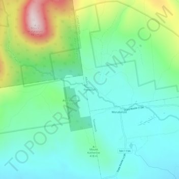
Name: Topografische Karte Ferncroft, Höhe, Relief.
Durchschnittliche Höhe: 439 m
Minimale Höhe: 289 m
Maximale Höhe: 847 m
Andere topografische Karten
Klicken Sie auf eine Karte, um ihre Topografie, ihre Höhe und ihr Relief anzuzeigen.
North Conway
United States > New Hampshire > Carroll County > Conway
North Conway, Conway, Carroll County, New Hampshire, 03860, United States
Durchschnittliche Höhe: 173 m
Big Attitash Mountain
United States > New Hampshire > Carroll County > Bartlett
Big Attitash Mountain, Bartlett, Carroll County, New Hampshire, United States
Durchschnittliche Höhe: 711 m
Eidelweiss Beach
United States > New Hampshire > Carroll County > Madison
Eidelweiss Beach, Madison, Carroll County, New Hampshire, United States
Durchschnittliche Höhe: 236 m
East Wakefield
United States > New Hampshire > Carroll County > Wakefield
East Wakefield, Wakefield, Carroll County, New Hampshire, 03830, United States
Durchschnittliche Höhe: 206 m
Center Conway
United States > New Hampshire > Carroll County > Conway
Center Conway, Conway, Carroll County, New Hampshire, 03813, United States
Durchschnittliche Höhe: 142 m
Albany
United States > New Hampshire > Carroll County
Albany, Carroll County, New Hampshire, United States
Durchschnittliche Höhe: 329 m
Melvin Village
United States > New Hampshire > Carroll County > Tuftonboro
Melvin Village, Tuftonboro, Carroll County, New Hampshire, 03850, United States
Durchschnittliche Höhe: 181 m
Brookfield
United States > New Hampshire > Carroll County
Brookfield, Carroll County, New Hampshire, United States
Durchschnittliche Höhe: 235 m
Center Sandwich
United States > New Hampshire > Carroll County > Sandwich
Center Sandwich, Sandwich, Carroll County, New Hampshire, 03227, United States
Durchschnittliche Höhe: 227 m
Lees Mill
United States > New Hampshire > Carroll County > Moultonborough
Lees Mill, Moultonborough, Carroll County, New Hampshire, 03254, United States
Durchschnittliche Höhe: 173 m
Wolfeboro Falls
United States > New Hampshire > Carroll County > Wolfeboro
Wolfeboro Falls, Wolfeboro, Carroll County, New Hampshire, 03894, United States
Durchschnittliche Höhe: 181 m
Union
United States > New Hampshire > Carroll County > Wakefield
Union, Wakefield, Carroll County, New Hampshire, 03887, United States
Durchschnittliche Höhe: 176 m
Kearsarge
United States > New Hampshire > Carroll County > Conway
Kearsarge, Conway, Carroll County, New Hampshire, 03847, United States
Durchschnittliche Höhe: 272 m
Center Ossipee
United States > New Hampshire > Carroll County > Ossipee
Center Ossipee, Ossipee, Carroll County, New Hampshire, 03814, United States
Durchschnittliche Höhe: 157 m
Chocorua
United States > New Hampshire > Carroll County > Tamworth
Chocorua, Tamworth, Carroll County, New Hampshire, 03817, United States
Durchschnittliche Höhe: 202 m
Redstone
United States > New Hampshire > Carroll County > Conway
Redstone, Conway, Carroll County, New Hampshire, 03860, United States
Durchschnittliche Höhe: 185 m
Silver Lake
United States > New Hampshire > Carroll County > Madison
Silver Lake, Madison, Carroll County, New Hampshire, United States
Durchschnittliche Höhe: 162 m
West Ossipee
United States > New Hampshire > Carroll County > Ossipee
West Ossipee, Ossipee, Carroll County, New Hampshire, 03890, United States
Durchschnittliche Höhe: 167 m
Hart's Location
United States > New Hampshire > Carroll County
Hart's Location, Carroll County, New Hampshire, United States
Durchschnittliche Höhe: 706 m
Wonalancet
United States > New Hampshire > Carroll County > Tamworth
Wonalancet, Tamworth, Carroll County, New Hampshire, 03897, United States
Durchschnittliche Höhe: 391 m
South Tamworth
United States > New Hampshire > Carroll County > Tamworth
South Tamworth, Tamworth, Carroll County, New Hampshire, 03883, United States
Durchschnittliche Höhe: 265 m
Wolfeboro
United States > New Hampshire > Carroll County
Wolfeboro, Carroll County, New Hampshire, United States
Durchschnittliche Höhe: 213 m
Flat Mountain
United States > New Hampshire > Carroll County > Sandwich
Flat Mountain, Sandwich, Carroll County, New Hampshire, United States
Durchschnittliche Höhe: 629 m
Lake Wentworth
United States > New Hampshire > Carroll County > Wolfeboro
Lake Wentworth, Wolfeboro, Carroll County, New Hampshire, United States
Durchschnittliche Höhe: 180 m
Ossipee Lake
United States > New Hampshire > Carroll County > Freedom
Ossipee Lake, Freedom, Carroll County, New Hampshire, United States
Durchschnittliche Höhe: 127 m
Ossipee
United States > New Hampshire > Carroll County
Ossipee, Carroll County, New Hampshire, United States
Durchschnittliche Höhe: 217 m
East Freedom
United States > New Hampshire > Carroll County > Freedom
East Freedom, Freedom, Carroll County, New Hampshire, United States
Durchschnittliche Höhe: 144 m
South Chatham
United States > New Hampshire > Carroll County > Chatham
South Chatham, Chatham, Carroll County, New Hampshire, United States
Durchschnittliche Höhe: 163 m
Mount Chocorua
United States > New Hampshire > Carroll County > Albany
Mount Chocorua, Albany, Carroll County, New Hampshire, United States
Durchschnittliche Höhe: 736 m
Sawyers River
United States > New Hampshire > Carroll County > Hart's Location
Sawyers River, Hart's Location, Carroll County, New Hampshire, United States
Durchschnittliche Höhe: 457 m
Wakefield
United States > New Hampshire > Carroll County
Wakefield, Carroll County, New Hampshire, United States
Durchschnittliche Höhe: 218 m
Moultonborough
United States > New Hampshire > Carroll County
Moultonborough, Carroll County, New Hampshire, United States
Durchschnittliche Höhe: 243 m
Goose Corner
United States > New Hampshire > Carroll County > Wolfeboro
Goose Corner, Wolfeboro, Carroll County, New Hampshire, 03984, United States
Durchschnittliche Höhe: 189 m
Glen
United States > New Hampshire > Carroll County > Bartlett
Glen, Bartlett, Carroll County, New Hampshire, 03838, United States
Durchschnittliche Höhe: 240 m
Sandwich
United States > New Hampshire > Carroll County
Sandwich, Carroll County, New Hampshire, 03259, United States
Durchschnittliche Höhe: 373 m
Mount Washington Valley
United States > New Hampshire > Carroll County > Conway > North Conway
Mount Washington Valley, North Conway, Conway, Carroll County, New Hampshire, 03860, United States
Durchschnittliche Höhe: 250 m
Bill Rae Conservation Area
United States > New Hampshire > Carroll County > Wolfeboro > Stockbridge Corner
Bill Rae Conservation Area, Stockbridge Corner, Wolfeboro, Carroll County, New Hampshire, United States
Durchschnittliche Höhe: 244 m
Tuftonboro
United States > New Hampshire > Carroll County
Tuftonboro, Carroll County, New Hampshire, United States
Durchschnittliche Höhe: 256 m
Brookfield
United States > New Hampshire > Carroll County > Brookfield
Brookfield, Carroll County, New Hampshire, 03872, United States
Durchschnittliche Höhe: 195 m
Mount Willard
United States > New Hampshire > Carroll County > Hart's Location
Mount Willard, Hart's Location, Carroll County, New Hampshire, United States
Durchschnittliche Höhe: 775 m
North Sandwich
United States > New Hampshire > Carroll County > Sandwich
North Sandwich, Sandwich, Carroll County, New Hampshire, 03259, United States
Durchschnittliche Höhe: 233 m
Sanbornville
United States > New Hampshire > Carroll County > Wakefield
Sanbornville, Wakefield, Carroll County, New Hampshire, 03872, United States
Durchschnittliche Höhe: 185 m
Thurley Mountain
United States > New Hampshire > Carroll County > Ossipee
Thurley Mountain, Ossipee, Carroll County, New Hampshire, United States
Durchschnittliche Höhe: 386 m
Eaton
United States > New Hampshire > Carroll County
Eaton, Carroll County, New Hampshire, 03832, United States
Durchschnittliche Höhe: 262 m
Thorn Hill
United States > New Hampshire > Carroll County > Bartlett
Thorn Hill, Bartlett, Carroll County, New Hampshire, 03838, United States
Durchschnittliche Höhe: 311 m
Mirror Lake
United States > New Hampshire > Carroll County > Tuftonboro > Mirror Lake
Mirror Lake, Tuftonboro, Carroll County, New Hampshire, United States
Durchschnittliche Höhe: 169 m
Intervale
United States > New Hampshire > Carroll County > Conway
Intervale, Conway, Carroll County, New Hampshire, 03845, United States
Durchschnittliche Höhe: 198 m
Crawford Notch State Park
United States > New Hampshire > Carroll County > Hart's Location
Crawford Notch State Park, Hart's Location, Carroll County, New Hampshire, United States
Durchschnittliche Höhe: 796 m
Effingham
United States > New Hampshire > Carroll County
Effingham, Carroll County, New Hampshire, 03882, United States
Durchschnittliche Höhe: 188 m
Freedom
United States > New Hampshire > Carroll County
Freedom, Carroll County, New Hampshire, 03836, United States
Durchschnittliche Höhe: 224 m