Geolokalisieren

Topografische Karte Oneida County

Interaktive Karte

Klicken Sie auf die Karte, um die Höhe anzuzeigen.

Oneida County

Oxford Peak is the highest point in the county at 9,285 ft (2,830 m) above sea level. Alternating valleys and ridges of mountains or hills typify the topography, with grassland and sagebrush covering most areas. The Curlew National Grassland lies within the county.

Wikipedia (CC-BY-SA 3.0)

Über diese Karte

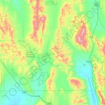
Name: Topografische Karte Oneida County, Höhe, Relief.

Ort: Oneida County, Idaho, United States (41.99724 -113.00008 42.50306 -112.07027)

Durchschnittliche Höhe: 1.678 m

Minimale Höhe: 1.325 m

Maximale Höhe: 2.747 m

Andere topografische Karten

Klicken Sie auf eine Karte, um ihre Topografie, ihre Höhe und ihr Relief anzuzeigen.

Boise

United States > Idaho > Ada County

Boise (locally /ˈbɔɪsi/ BOY-see) is the capital and most populous city of the U.S. state of Idaho and is the county seat of Ada County. As of the 2020 census, there were 235,684 people residing in the city. On the Boise River in southwestern Idaho, it is 41 miles (66 km) east of the Oregon border and 110…

Durchschnittliche Höhe: 1.040 m

Scotchman Peak

United States > Idaho > Bonner County

Durchschnittliche Höhe: 1.727 m

Fossil Butte

United States > Idaho > Owyhee County

Durchschnittliche Höhe: 942 m

Del Monte

United States > Idaho > Gem County

Durchschnittliche Höhe: 715 m

Cobalt

United States > Idaho > Lemhi County

Durchschnittliche Höhe: 1.786 m

Placerville

United States > Idaho > Boise County

Durchschnittliche Höhe: 1.343 m

Chilly

United States > Idaho > Custer County

Durchschnittliche Höhe: 1.924 m

Page

United States > Idaho > Shoshone County

Durchschnittliche Höhe: 822 m

Pollock

United States > Idaho > Idaho County

Durchschnittliche Höhe: 913 m

Gannett

United States > Idaho > Blaine County

Durchschnittliche Höhe: 1.510 m

Tendoy

United States > Idaho > Lemhi County

Durchschnittliche Höhe: 1.496 m

Fish Lake

United States > Idaho > Clearwater County

Durchschnittliche Höhe: 1.893 m

Admiral Peak

United States > Idaho > Clearwater County

Durchschnittliche Höhe: 1.878 m

Cocolalla

United States > Idaho > Bonner County

Durchschnittliche Höhe: 754 m

Thunder Mountain

United States > Idaho > Cassia County

Durchschnittliche Höhe: 1.991 m

Atlanta

United States > Idaho > Elmore County

Durchschnittliche Höhe: 1.820 m

Dixie

United States > Idaho > Idaho County

Durchschnittliche Höhe: 1.781 m

Virgil Phillips Farm Park

United States > Idaho > Latah County

Durchschnittliche Höhe: 898 m

Vay

United States > Idaho > Bonner County

Durchschnittliche Höhe: 698 m

Moon Peak

United States > Idaho > Shoshone County

Durchschnittliche Höhe: 1.453 m

McDonald Lake

United States > Idaho > Custer County

Durchschnittliche Höhe: 2.241 m

Centerville

United States > Idaho > Boise County

Durchschnittliche Höhe: 1.316 m

Rabbit Mountain

United States > Idaho > Caribou County

Durchschnittliche Höhe: 1.880 m

Lignite

United States > Idaho > Bonner County

Durchschnittliche Höhe: 690 m

Warm Lake

United States > Idaho > Valley County > Warm Lake

Durchschnittliche Höhe: 1.641 m

Clarkia

United States > Idaho > Shoshone County

Durchschnittliche Höhe: 929 m

Diamond Point

United States > Idaho > Valley County

Durchschnittliche Höhe: 2.067 m

Blue Rock Lake

United States > Idaho > Boise County

Durchschnittliche Höhe: 2.632 m

Shoshone Falls

United States > Idaho > Jerome County

Durchschnittliche Höhe: 1.107 m

Hyndman Peak

United States > Idaho > Blaine County

Hyndman Peak, at an elevation of 12,012 feet (3,661 m) above sea level, is the ninth highest peak in Idaho and the highest point in the Pioneer Mountains, Sawtooth National Forest, and Blaine County. Hyndman Peak is located on the border of Custer and Blaine counties. The towns of Hailey, Ketchum, and Sun…

Durchschnittliche Höhe: 3.170 m

Sugar Bowl

United States > Idaho > Elmore County

Durchschnittliche Höhe: 799 m

Woodville

United States > Idaho > Bingham County

Durchschnittliche Höhe: 1.413 m

North Fork

United States > Idaho > Lemhi County

Durchschnittliche Höhe: 1.339 m

Ovid

United States > Idaho > Bear Lake County

Durchschnittliche Höhe: 1.814 m

Fischer Island

United States > Idaho > Canyon County

Durchschnittliche Höhe: 729 m

South Butte

United States > Idaho > Shoshone County

Durchschnittliche Höhe: 1.861 m

Turkey Point

United States > Idaho > Shoshone County

Durchschnittliche Höhe: 1.604 m

Blanchard

United States > Idaho > Bonner County

Durchschnittliche Höhe: 718 m

Nugget Point

United States > Idaho > Idaho County

Durchschnittliche Höhe: 1.659 m

Bayview

United States > Idaho > Kootenai County

Bayview is an unincorporated community in the northwest United States, located in Kootenai County, Idaho, north of Coeur d'Alene. On the southwest shore of Lake Pend Oreille, Bayview is seven miles (11 km) east-northeast of Athol. The community is served by State Highway 54 and a post office with ZIP code…

Durchschnittliche Höhe: 733 m

Packsaddle Lake

United States > Idaho > Teton County

Durchschnittliche Höhe: 2.331 m

Mount Baldy

United States > Idaho > Bonneville County

Durchschnittliche Höhe: 2.089 m

Smoky Mountain

United States > Idaho > Cassia County

Durchschnittliche Höhe: 1.976 m

Box Canyon

United States > Idaho > Fremont County

Durchschnittliche Höhe: 1.891 m

Heglar

United States > Idaho > Cassia County

Durchschnittliche Höhe: 1.480 m

Wheaton Mountain

United States > Idaho > Bonneville County

Durchschnittliche Höhe: 1.855 m

Cataldo

United States > Idaho > Kootenai County

Durchschnittliche Höhe: 732 m

Snake River

United States > Idaho > Washington County

Due to the rain shadow effect of the Cascades, precipitation as a whole is scant, averaging 14 inches (360 mm) across the entire watershed. Most precipitation falls at higher elevations as snow, thus, most runoff in the Snake River watershed derives from snowmelt. Jackson Hole, Wyoming experiences an alpine…

Durchschnittliche Höhe: 644 m

tiger peak

United States > Idaho > Shoshone County

Durchschnittliche Höhe: 1.711 m

The Maze

United States > Idaho > Idaho County

Durchschnittliche Höhe: 533 m

Garden Valley

United States > Idaho > Boise County

Durchschnittliche Höhe: 1.004 m

Ben Ross Reservoir

United States > Idaho > Adams County

Durchschnittliche Höhe: 969 m

Sawtell Peak

United States > Idaho > Fremont County

Durchschnittliche Höhe: 2.661 m

Chicken Peak

United States > Idaho > Bonneville County

Durchschnittliche Höhe: 2.325 m

Malad Summit

United States > Idaho > Oneida County

Durchschnittliche Höhe: 1.715 m

Hayden

United States > Idaho > Kootenai County

Durchschnittliche Höhe: 717 m

Buckhorn Summit

United States > Idaho > Valley County

Durchschnittliche Höhe: 2.294 m

Canida Peak

United States > Idaho > Boundary County

Durchschnittliche Höhe: 1.345 m

Kingston

United States > Idaho > Shoshone County

Durchschnittliche Höhe: 730 m

Redfish Lake

United States > Idaho > Custer County

The surface elevation of Redfish Lake is 6,547 feet (1,996 m) above sea level. The lake is 4.5 miles (7.2 km) long and 0.72 miles (1.2 km) wide, with a maximum depth of 387 feet (118 m), and 11 miles (18 km) of shoreline. The actual trail around the lake is 17.5 miles (28 km) in length.

Durchschnittliche Höhe: 2.144 m

Snake River

United States > Idaho

Mountain ranges in the Snake watershed include the Teton Range, Bitterroot Range, Clearwater Mountains, Seven Devils Mountains, and the extreme northwestern end of the Wind River Range. Grand Teton is the highest point in the Snake River watershed, reaching 13,775 feet (4,199 m) in elevation. The elevation of…

Durchschnittliche Höhe: 644 m

Dry Can Creek

United States > Idaho > Idaho County

Durchschnittliche Höhe: 1.163 m

Banks

United States > Idaho > Boise County > Banks

Durchschnittliche Höhe: 1.184 m

Meridian

United States > Idaho > Ada County > Meridian

Durchschnittliche Höhe: 834 m

Spion Kop

United States > Idaho > Shoshone County

Durchschnittliche Höhe: 1.436 m

Bitterroot Mountain

United States > Idaho > Lemhi County

Durchschnittliche Höhe: 2.298 m

Chief

United States > Idaho > Valley County

Durchschnittliche Höhe: 2.249 m

McDonalds

United States > Idaho > Shoshone County

Durchschnittliche Höhe: 1.692 m

Budge

United States > Idaho

Durchschnittliche Höhe: 1.266 m

Fivemile Creek

United States > Idaho > Ada County > Meridian

Durchschnittliche Höhe: 779 m

Devils Point

United States > Idaho

Durchschnittliche Höhe: 2.283 m

Bingham County

United States > Idaho

Durchschnittliche Höhe: 1.397 m

Garden Valley

United States > Idaho > Garden Valley

Durchschnittliche Höhe: 1.004 m

Twin Falls

United States > Idaho > Twin Falls County > Twin Falls

Durchschnittliche Höhe: 1.189 m

Marsh Creek

United States > Idaho > Valley County

Durchschnittliche Höhe: 2.269 m

Platinum Lake

United States > Idaho > Clearwater County

Durchschnittliche Höhe: 1.723 m