
Topografische Karte French Guiana
Interaktive Karte
Klicken Sie auf die Karte, um die Höhe anzuzeigen.
Über diese Karte
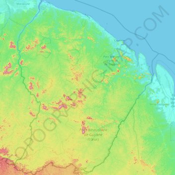
Name: Topografische Karte French Guiana, Höhe, Relief.
Ort: French Guiana, France (2.11094 -54.60269 5.77695 -51.63461)
Durchschnittliche Höhe: 103 m
Minimale Höhe: -2 m
Maximale Höhe: 791 m
French Guiana has an equatorial climate predominant. Located within six degrees of the Equator and rising only to modest elevations, French Guiana is hot and oppressively humid all year round. During most of the year, rainfall across the country is heavy due to the presence of the Intertropical Convergence Zone and its powerful thunderstorm cells. In most parts of French Guiana, rainfall is always heavy especially from December to July – typically over 330 millimetres or 13 inches can be expected each month during this period throughout the department. Between August and November, the eastern half experiences a warm dry season with rainfall below 100 millimetres or 3.94 inches and average high temperatures above 30 °C (86 °F) occurring in September and October, causing eastern French Guiana to be classified as a tropical monsoon climate (Köppen Am); Saint-Laurent-du-Maroni in the west has a tropical rainforest climate (Af).
Andere topografische Karten
Klicken Sie auf eine Karte, um ihre Topografie, ihre Höhe und ihr Relief anzuzeigen.
Rencurel
France > Auvergne-Rhône-Alpes > Isère
Rencurel, Grenoble, Isère, Auvergne-Rhône-Alpes, Metropolitan France, 38680, France
Durchschnittliche Höhe: 1.099 m
Le Grand-Lemps
France > Auvergne-Rhône-Alpes > Isère
Le Grand-Lemps, La Tour-du-Pin, Isère, Auvergne-Rhône-Alpes, Metropolitan France, 38690, France
Durchschnittliche Höhe: 512 m
city de boutet de monvel (ethanlecartographe
France > Grand Est > Meurthe-et-Moselle > Lunéville
city de boutet de monvel (ethanlecartographe, Lunéville, Meurthe-et-Moselle, Grand Est, Metropolitan France, 54300, France
Durchschnittliche Höhe: 240 m
Isère
Isère, Auvergne-Rhône-Alpes, Metropolitan France, France
Durchschnittliche Höhe: 868 m
Rambe
France > Auvergne-Rhône-Alpes > Puy-de-Dôme > Peschadoires
Rambe, Peschadoires, Thiers, Puy-de-Dôme, Auvergne-Rhône-Alpes, Metropolitan France, 63920, France
Durchschnittliche Höhe: 361 m
Quéant
France > Hauts-de-France > Pas-de-Calais
Quéant, Arras, Pas-de-Calais, Hauts-de-France, Metropolitan France, 62860, France
Durchschnittliche Höhe: 85 m
Fontaine
France > Auvergne-Rhône-Alpes > Isère
Fontaine, Grenoble, Isère, Auvergne-Rhône-Alpes, Metropolitan France, 38600, France
Durchschnittliche Höhe: 253 m
Le Born
France > Occitania > Haute-Garonne
Le Born, Toulouse, Haute-Garonne, Occitania, Metropolitan France, 31340, France
Durchschnittliche Höhe: 169 m
Noreuil
France > Hauts-de-France > Pas-de-Calais
Noreuil, Arras, Pas-de-Calais, Hauts-de-France, Metropolitan France, 62128, France
Durchschnittliche Höhe: 97 m
Montagnole
France > Auvergne-Rhône-Alpes > Savoy
Montagnole, Chambéry, Savoy, Auvergne-Rhône-Alpes, Metropolitan France, 73000, France
Durchschnittliche Höhe: 685 m
Mézos
France > Nouvelle-Aquitaine > Landes
Mézos, Mont-de-Marsan, Landes, Nouvelle-Aquitaine, Metropolitan France, 40170, France
Durchschnittliche Höhe: 40 m
Village Tumukuru
France > French Polynesia > Tatakoto
Village Tumukuru, Tatakoto, Tuamotu-Gambier, French Polynesia, 98783, France
Durchschnittliche Höhe: 1 m
Champniers
France > Nouvelle-Aquitaine > Charente
Champniers, Angoulême, Charente, Nouvelle-Aquitaine, Metropolitan France, 16430, France
Durchschnittliche Höhe: 92 m
Montferrand
Montferrand, Carcassonne, Aude, Occitania, Metropolitan France, 11320, France
Durchschnittliche Höhe: 222 m
Ain
Ain, Auvergne-Rhône-Alpes, Metropolitan France, France
Durchschnittliche Höhe: 418 m
Rangiroa
France > French Polynesia > Rangiroa
Rangiroa, Tuamotu-Gambier, French Polynesia, 98775, France
Durchschnittliche Höhe: 0 m
Maine-et-Loire
Maine-et-Loire, Pays de la Loire, Metropolitan France, France
Durchschnittliche Höhe: 76 m
Custines
France > Grand Est > Meurthe-et-Moselle
Custines, Nancy, Meurthe-et-Moselle, Grand Est, Metropolitan France, 54670, France
Durchschnittliche Höhe: 275 m
Sus
France > Nouvelle-Aquitaine > Pyrénées-Atlantiques
Sus, Oloron-Sainte-Marie, Pyrénées-Atlantiques, Nouvelle-Aquitaine, Metropolitan France, 64190, France
Durchschnittliche Höhe: 162 m
Domaine de Saint-Lambert
France > Occitania > Lozère > Marvejols
Domaine de Saint-Lambert, Promenade Louis Cabanettes, Marvejols, Mende, Lozère, Occitania, Metropolitan France, 48100, France
Durchschnittliche Höhe: 725 m
Pregnin
France > Auvergne-Rhône-Alpes > Ain > Saint-Genis-Pouilly
Pregnin, Saint-Genis-Pouilly, Gex, Ain, Auvergne-Rhône-Alpes, Metropolitan France, 01630, France
Durchschnittliche Höhe: 473 m
Paris
Paris, Ile-de-France, Metropolitan France, France
Durchschnittliche Höhe: 59 m
Saint-Pierre-de-Cernières
Saint-Pierre-de-Cernières, Bernay, Eure, Normandy, Metropolitan France, 27390, France
Durchschnittliche Höhe: 201 m
Le Not
France > Auvergne-Rhône-Alpes > Isère > Saint-Hilaire-de-la-Côte
Le Not, Saint-Hilaire-de-la-Côte, Vienne, Isère, Auvergne-Rhône-Alpes, Metropolitan France, 38260, France
Durchschnittliche Höhe: 406 m
Entrange Cité
Entrange Cité, Entrange, Thionville, Moselle, Grand Est, Metropolitan France, 57330, France
Durchschnittliche Höhe: 237 m
Saint-Nazaire
France > Pays de la Loire > Loire-Atlantique
Saint-Nazaire, Loire-Atlantique, Pays de la Loire, Metropolitan France, 44600, France
Durchschnittliche Höhe: 6 m
Cachar
France > Occitania > Gard > Saint-Jean-du-Gard
Cachar, Saint-Jean-du-Gard, Alès, Gard, Occitania, Metropolitan France, 30270, France
Durchschnittliche Höhe: 312 m
Mandrel
France > Grand Est > Aube > Lignol-le-Château
Mandrel, Lignol-le-Château, Bar-sur-Aube, Aube, Grand Est, Metropolitan France, 10200, France
Durchschnittliche Höhe: 262 m
Sénestis
France > Nouvelle-Aquitaine > Lot-et-Garonne
Sénestis, Marmande, Lot-et-Garonne, Nouvelle-Aquitaine, Metropolitan France, 47430, France
Durchschnittliche Höhe: 32 m
Entremont
France > Auvergne-Rhône-Alpes > Upper Savoy > Glières-Val-de-Borne
Entremont, Glières-Val-de-Borne, Bonneville, Upper Savoy, Auvergne-Rhône-Alpes, Metropolitan France, 74130, France
Durchschnittliche Höhe: 1.302 m
Juan de Nova Island
France > French Southern and Antarctic Lands
Juan de Nova Island, Scattered Islands in the Indian Ocean, French Southern and Antarctic Lands, France
Durchschnittliche Höhe: 0 m
Mane
France > Occitania > Haute-Garonne
Mane, Saint-Gaudens, Haute-Garonne, Occitania, Metropolitan France, 31260, France
Durchschnittliche Höhe: 338 m
Massongy
France > Auvergne-Rhône-Alpes > Upper Savoy
Massongy, Thonon-les-Bains, Upper Savoy, Auvergne-Rhône-Alpes, Metropolitan France, 74140, France
Durchschnittliche Höhe: 454 m
Vensac
France > Nouvelle-Aquitaine > Gironde
Vensac, Lesparre-Médoc, Gironde, Nouvelle-Aquitaine, Metropolitan France, 33590, France
Durchschnittliche Höhe: 4 m
Nocha
France > Grand Est > Vosges > Autreville
Nocha, Autreville, Neufchâteau, Vosges, Grand Est, Metropolitan France, 88300, France
Durchschnittliche Höhe: 309 m