
Topografische Karte Mountrail County
Interaktive Karte
Klicken Sie auf die Karte, um die Höhe anzuzeigen.
Über diese Karte
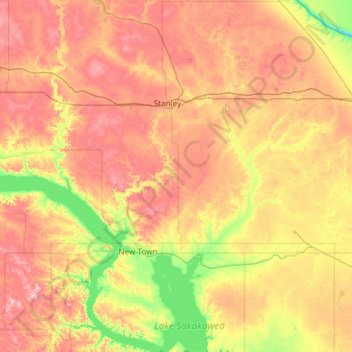
Name: Topografische Karte Mountrail County, Höhe, Relief.
Ort: Mountrail County, North Dakota, United States (47.75250 -102.88712 48.54830 -101.87148)
Durchschnittliche Höhe: 659 m
Minimale Höhe: 525 m
Maximale Höhe: 838 m
Andere topografische Karten
Klicken Sie auf eine Karte, um ihre Topografie, ihre Höhe und ihr Relief anzuzeigen.
Fargo
United States > North Dakota > Cass County
Fargo, Cass County, North Dakota, United States
Durchschnittliche Höhe: 277 m
Horace
United States > North Dakota > Cass County
Horace, Cass County, North Dakota, United States
Durchschnittliche Höhe: 278 m
Epping
United States > North Dakota > Williams County
Epping, Williams County, North Dakota, United States
Durchschnittliche Höhe: 676 m
Elgin
United States > North Dakota > Grant County
Elgin, Grant County, North Dakota, 58533, United States
Durchschnittliche Höhe: 716 m
Grand Forks
United States > North Dakota > Grand Forks County
Grand Forks, Grand Forks County, North Dakota, United States
Durchschnittliche Höhe: 255 m
Kindred
United States > North Dakota > Cass County
Kindred, Cass County, North Dakota, United States
Durchschnittliche Höhe: 288 m
Kidder County
Kidder County, North Dakota, United States
Durchschnittliche Höhe: 569 m
Hatton
United States > North Dakota > Traill County
Hatton, Traill County, North Dakota, United States
Durchschnittliche Höhe: 329 m
Flaxton
United States > North Dakota > Burke County
Flaxton, Burke County, North Dakota, United States
Durchschnittliche Höhe: 589 m
Forbes
United States > North Dakota > Dickey County
Forbes, Dickey County, North Dakota, United States
Durchschnittliche Höhe: 476 m
Jamestown
United States > North Dakota > Jamestown
Jamestown, Stutsman County, North Dakota, United States
Durchschnittliche Höhe: 451 m
Belfield
United States > North Dakota > Stark County
Belfield, Stark County, North Dakota, 58622, United States
Durchschnittliche Höhe: 799 m
Fort Yates
United States > North Dakota > Sioux County > Fort Yates > Fort Yates
Fort Yates, Fort Yates District, Sioux County, North Dakota, 58538, United States
Durchschnittliche Höhe: 499 m
Burke County
United States > North Dakota > Burke County
Burke County, North Dakota, United States
Durchschnittliche Höhe: 645 m
Brisbane
United States > North Dakota > Grant County > Brisbane
Brisbane, Grant County, North Dakota, United States
Durchschnittliche Höhe: 733 m
Williams County
United States > North Dakota > Williams County
Williams County, North Dakota, United States
Durchschnittliche Höhe: 663 m
Fargo
United States > North Dakota > Cass County > Fargo
Fargo, Cass County, North Dakota, 58102-4608, United States
Durchschnittliche Höhe: 277 m
Harwood
United States > North Dakota > Cass County > Harwood
Harwood, Cass County, North Dakota, 58042, United States
Durchschnittliche Höhe: 272 m
Abercrombie
United States > North Dakota > Richland County > Abercrombie
Abercrombie, Richland County, North Dakota, 58001, United States
Durchschnittliche Höhe: 286 m
Donnybrook
United States > North Dakota > Ward County > Donnybrook
Donnybrook, Ward County, North Dakota, United States
Durchschnittliche Höhe: 569 m
Linton
United States > North Dakota > Emmons County
Linton, Emmons County, North Dakota, 58552, United States
Durchschnittliche Höhe: 540 m
Glenburn
United States > North Dakota > Renville County > Glenburn
Glenburn, Renville County, North Dakota, United States
Durchschnittliche Höhe: 477 m
Minto
United States > North Dakota > Walsh County
Minto, Walsh County, North Dakota, United States
Durchschnittliche Höhe: 249 m
Slope County
Slope County, North Dakota, United States
Durchschnittliche Höhe: 860 m
Mountain
United States > North Dakota > Mountain
Mountain, Pembina County, North Dakota, United States
Durchschnittliche Höhe: 325 m
Ward County
Ward County, North Dakota, United States
Durchschnittliche Höhe: 579 m
Oberon
United States > North Dakota > Benson County
Oberon, Benson County, North Dakota, United States
Durchschnittliche Höhe: 474 m
Finley
United States > North Dakota > Steele County
Finley, Steele County, North Dakota, United States
Durchschnittliche Höhe: 439 m
Glenfield
United States > North Dakota > Foster County
Glenfield, Foster County, North Dakota, United States
Durchschnittliche Höhe: 457 m
Eddy County
Eddy County, North Dakota, United States
Durchschnittliche Höhe: 464 m
Carrington
United States > North Dakota > Foster County
Carrington, Foster County, North Dakota, 58421, United States
Durchschnittliche Höhe: 484 m
Walhalla
United States > North Dakota > Pembina County
Walhalla, Pembina County, North Dakota, United States
Durchschnittliche Höhe: 303 m
Kenmare
United States > North Dakota > Kenmare
Kenmare, Ward County, North Dakota, United States
Durchschnittliche Höhe: 577 m
Gascoyne
United States > North Dakota > Bowman County > Gascoyne
Gascoyne, Bowman County, North Dakota, United States
Durchschnittliche Höhe: 842 m
Burleigh County
Burleigh County, North Dakota, United States
Durchschnittliche Höhe: 572 m
Foster County
Foster County, North Dakota, United States
Durchschnittliche Höhe: 473 m
Divide County
Divide County, North Dakota, United States
Durchschnittliche Höhe: 650 m