
Topografische Karte Calipatria
Interaktive Karte
Klicken Sie auf die Karte, um die Höhe anzuzeigen.
Über diese Karte
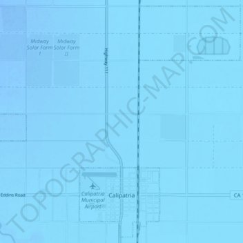
Name: Topografische Karte Calipatria, Höhe, Relief.
Ort: Calipatria, Imperial County, California, United States (33.11432 -115.55409 33.17660 -115.47595)
Durchschnittliche Höhe: -50 m
Minimale Höhe: -60 m
Maximale Höhe: -37 m
At an elevation of 180 feet (55 m) below sea level, Calipatria is the lowest incorporated city in the Western Hemisphere. The city currently claims to have the "tallest flagpole (184 feet) where the flag flies at sea level" at 184 feet (56 m), so their American flag will always fly above sea level. According to the Guinness Book of World Records, the Jeddah Flagpole holds the title of world's tallest, but it is entirely above sea level.
Andere topografische Karten
Klicken Sie auf eine Karte, um ihre Topografie, ihre Höhe und ihr Relief anzuzeigen.
Heber
United States > California > Imperial County
Heber, Imperial County, California, 92224, United States
Durchschnittliche Höhe: -3 m
Rico
United States > California > Imperial County
Rico, Imperial County, CAL Fire Southern Region, California, 92250, United States
Durchschnittliche Höhe: -7 m
Salton Sea
United States > California > Imperial County
Salton Sea, Imperial County, California, United States
Durchschnittliche Höhe: 9 m
Superstition Mountain
United States > California > Imperial County
Superstition Mountain, Imperial County, California, United States
Durchschnittliche Höhe: 130 m
Salton City
United States > California > Imperial County
Salton City, Imperial County, California, 92275, United States
Durchschnittliche Höhe: -35 m
Niland
United States > California > Imperial County > Niland
Niland, Imperial County, California, United States
Durchschnittliche Höhe: -40 m
Calipatria
United States > California > Imperial County > Calipatria
Calipatria, Imperial County, California, United States
Durchschnittliche Höhe: -53 m
Desert Shores
United States > California > Imperial County
Desert Shores, Imperial County, California, United States
Durchschnittliche Höhe: -58 m
El Centro
United States > California > Imperial County
El Centro, Imperial County, CAL Fire Southern Region, California, 92243, United States
Durchschnittliche Höhe: -10 m