
Topografische Karte Salton City
Interaktive Karte
Klicken Sie auf die Karte, um die Höhe anzuzeigen.
Über diese Karte
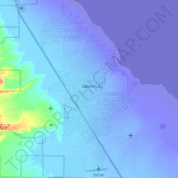
Name: Topografische Karte Salton City, Höhe, Relief.
Durchschnittliche Höhe: -35 m
Minimale Höhe: -72 m
Maximale Höhe: 88 m
In the 1970s, most of the buildings constructed along the shoreline, including the city's marina were abandoned due to rising sea elevation. In the 1980s, the Imperial Irrigation District took proactive water conservation measures to reduce the flow of unused canal water into the Salton Sea. Throughout the 1980s and 1990s, as salinity and suspected pollution levels in the Salton Sea increased, the attraction of the Salton Sea as a recreational destination diminished. Most of the original tourist related structures fell during this time, including the Truckhaven Cafe, the Salton Bay Yacht Club hotel and restaurant, and the Holly House motel and restaurant (later renamed Desser House and then the Sundowner).
Andere topografische Karten
Klicken Sie auf eine Karte, um ihre Topografie, ihre Höhe und ihr Relief anzuzeigen.
Heber
United States > California > Imperial County
Heber, Imperial County, California, 92224, United States
Durchschnittliche Höhe: -3 m
Rico
United States > California > Imperial County
Rico, Imperial County, CAL Fire Southern Region, California, 92250, United States
Durchschnittliche Höhe: -7 m
Salton Sea
United States > California > Imperial County
Salton Sea, Imperial County, California, United States
Durchschnittliche Höhe: 9 m
Superstition Mountain
United States > California > Imperial County
Superstition Mountain, Imperial County, California, United States
Durchschnittliche Höhe: 130 m
Calipatria
United States > California > Imperial County
Calipatria, Imperial County, California, United States
Durchschnittliche Höhe: -50 m
Niland
United States > California > Imperial County > Niland
Niland, Imperial County, California, United States
Durchschnittliche Höhe: -40 m
Calipatria
United States > California > Imperial County > Calipatria
Calipatria, Imperial County, California, United States
Durchschnittliche Höhe: -53 m
Desert Shores
United States > California > Imperial County
Desert Shores, Imperial County, California, United States
Durchschnittliche Höhe: -58 m
El Centro
United States > California > Imperial County
El Centro, Imperial County, CAL Fire Southern Region, California, 92243, United States
Durchschnittliche Höhe: -10 m