
Topografische Karte Moniaive
Interaktive Karte
Klicken Sie auf die Karte, um die Höhe anzuzeigen.
Über diese Karte
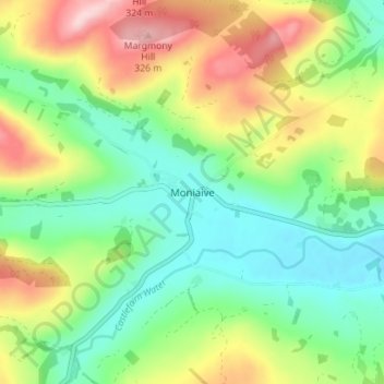
Name: Topografische Karte Moniaive, Höhe, Relief.
Durchschnittliche Höhe: 179 m
Minimale Höhe: 90 m
Maximale Höhe: 330 m
Andere topografische Karten
Klicken Sie auf eine Karte, um ihre Topografie, ihre Höhe und ihr Relief anzuzeigen.
Fingland
United Kingdom > Scotland > Dumfries and Galloway
Fingland, Dumfries and Galloway, Scotland, DG11 2LD, United Kingdom
Durchschnittliche Höhe: 206 m
Durisdeer
United Kingdom > Scotland > Dumfries and Galloway
Durisdeer, Dumfries and Galloway, Scotland, DG3 5BJ, United Kingdom
Durchschnittliche Höhe: 270 m
Eskdalemuir
United Kingdom > Scotland > Dumfries and Galloway
Eskdalemuir, Dumfries and Galloway, Scotland, DG13 0QF, United Kingdom
Durchschnittliche Höhe: 246 m
Doons
United Kingdom > Scotland > Dumfries and Galloway
Doons, Dumfries and Galloway, Scotland, DG3 4NG, United Kingdom
Durchschnittliche Höhe: 202 m