
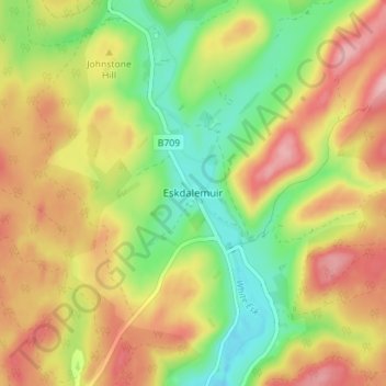
Topografische Karte Eskdalemuir
Interaktive Karte
Klicken Sie auf die Karte, um die Höhe anzuzeigen.
Über diese Karte
Name: Topografische Karte Eskdalemuir, Höhe, Relief.
Durchschnittliche Höhe: 246 m
Minimale Höhe: 175 m
Maximale Höhe: 319 m
In spite of it being located inland, the dull and wet nature of the climate due to the elevation leads to chilly summers that are colder than more northerly locations such as Glasgow and Edinburgh. The inland nature of the climate is more manifest during winter months with frosts being common, and the average lows between December and February are below the freezing point.
Andere topografische Karten
Klicken Sie auf eine Karte, um ihre Topografie, ihre Höhe und ihr Relief anzuzeigen.
Fingland
United Kingdom > Scotland > Dumfries and Galloway
Fingland, Dumfries and Galloway, Scotland, DG11 2LD, United Kingdom
Durchschnittliche Höhe: 206 m
Durisdeer
United Kingdom > Scotland > Dumfries and Galloway
Durisdeer, Dumfries and Galloway, Scotland, DG3 5BJ, United Kingdom
Durchschnittliche Höhe: 270 m
Moniaive
United Kingdom > Scotland > Dumfries and Galloway
Moniaive, Dumfries and Galloway, Scotland, DG3 4HN, United Kingdom
Durchschnittliche Höhe: 179 m
Doons
United Kingdom > Scotland > Dumfries and Galloway
Doons, Dumfries and Galloway, Scotland, DG3 4NG, United Kingdom
Durchschnittliche Höhe: 202 m